


Development platform
Targeting GIS secondary development users, we provide desktop components (MapGIS Objects SDK), plugins (MapGIS Desktop SDK), web front-end (MapGIS Client for JavaScript/MapGIS 3DClient for WebGL), mobile end (MapGIS Mobile SDK) and other development produ


MapGIS Mobile SDK is a fully functional GIS development platform for mobile devices, which can achieve 2D and 3D integrated offline/online map display, query, editing and analysis, and provide professional mobile application functions such as positioning and navigation, POI search, AR, etc., helping users quickly create mobile GIS applications suitable for various mainstream intelligent mobile devices.
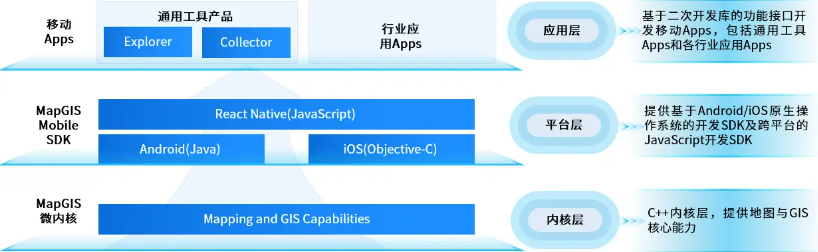
■MapGIS Mobile for Android SDK: A Development Kit for Native Android Development
■MapGIS Mobile for iOS SDK: A Development Kit for iOS Native Development
■MapGIS Mobile for ReactNative SDK: A Cross Platform Mobile Development Framework Based on React Native
Figure MapGIS Mobile SDK Development Framework

Figure MapGIS Mobile SDK Display of Development Results
Product Features
Comprehensive cross platform support
■Cross platform kernel, based on a unified cross platform GIS kernel, to achieve unified kernel for mobile, desktop, and server-side
■Cross platform data, using HDB high-performance file database for three end same source, with smaller files, better performance, and no migration
■Develop cross platform and provide open-source ReactNative SDK, suitable for multiple platforms in one development
Efficient cloud collaboration
■Seamless integration of MapGIS cloud GIS server and cloud portal for map service resources, OGC service resources, third-party service resources, and quick presentation on mobile devices
■Support multi-user data collection, remote/online multi terminal collection, synchronized updates to the server, and unified processing by desktop tools
Powerful full-featured support
■Efficient data collection, supporting accurate, hand drawn, and tracking collection methods, covering geographic elements and multimedia information
■Full space data management, supporting off/online grid vectors, fine models, oblique photography BIM、 20+data formats including point cloud
■Full space analysis and statistics, fully supporting 2D and 3D vector analysis, raster analysis, statistical analysis, etc., easy to expand
■Indoor and outdoor path planning and navigation, supporting industry and self collected road data, supporting integrated indoor and outdoor path calculation and navigation
■Deep integration of new technologies, supporting spatiotemporal big data rendering, vector tiles, and 3D AR applications
Product Usage
●For Android Link:http://www.smaryun.com/dev/download_detail.html#/download477
●for iOS Link:http://www.smaryun.com/dev/download_detail.html#/download662
Product technical resources
●for Android Resources:http://www.smaryun.com/dev/service-space/resource#/node_id520
●for iOS Resources:http://www.smaryun.com/dev/service-space/resource#/node_id539
●for RN Resources:http://www.smaryun.com/dev/service-space/resource#/node_id558
Related software
Desktop GIS
BD And Cloud Platforms
MapGIS CIM Basic Platform
Digital Twin Platform


