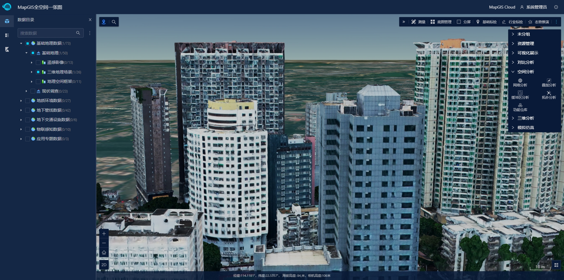
MapGIS Pan Spatial Map is based on the full spatial spatiotemporal information model, which realizes the integrated management, display, analysis, simulation, and professional application of aerial, surface, above ground, and underground spatiotemporal data, providing a customizable support framework for the development of "one industry map" applications.
Autonomous and controllable basic software and hardware environment support
Support multiple domestic chips and operating systems to ensure the security of geographic spatial information from the basic software and hardware environment:
●Supports mainstream CPU architectures and domestic chip platforms, including X86, ARM, MIPS, Alpha, LoongArch64, etc. Domestic chips support Feiteng, Kunpeng, Loongson, Shenwei, Zhaoxin, Haiguang, etc;
●Supports mainstream operating systems such as Windows and Linux, with Linux operating systems supporting RedHat, CentOS, Ubuntu, UOS, Zhongbiao Kirin, Galaxy Kirin, Deepness, Euler, Zhongke Fangde, Wanli Hong, Hongqi, etc;
●Mainstream domestic servers are supported, including Great Wall Optimus, Huawei Mount Taishan, Changjiang Computing, Haier, Baode, and Zhongke Dawning.
Integrated management of all spatial data
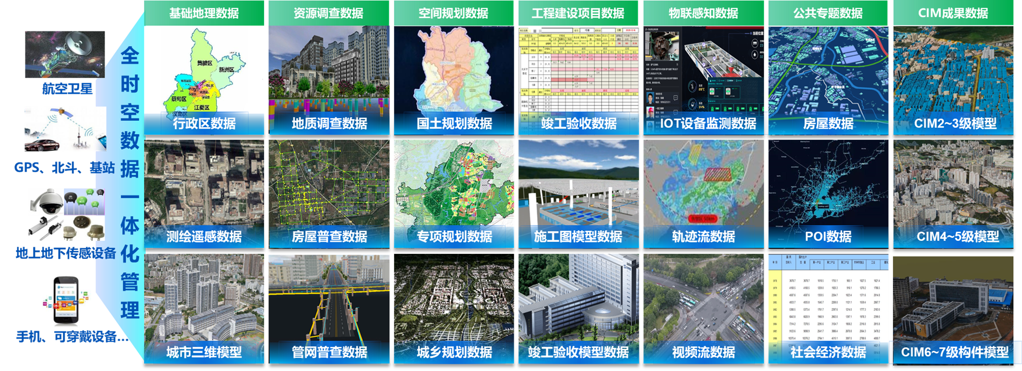
Based on the full space information model, establish data standards and classification standards suitable for industry needs, and achieve integrated management and diversified display of full space data.
●Support the construction of a full space data directory tree to achieve standardized management and unified access of full space data services through standard directory methods;
●Stereoscopic management of full space data, achieving integrated management of vector, image, model, slice, raster voxel and other full space data;
●Comprehensive auxiliary data association management can manage non spatial data related to batch, review, and inspection generated by various business units, including text, documents, images, videos, resource packages, etc., to achieve association management of business data related to spatial data;
●Multi type spatiotemporal data management can manage real-time data collected from various terminals, such as real-time dynamic IoT data monitored by sensors for logistics, vehicle flow, pedestrian flow, video flow, etc.
Stereoscopic fusion display of full space data
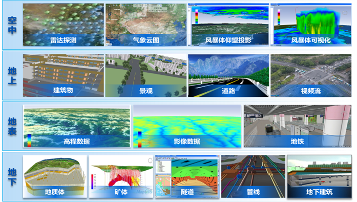
Integrating ground landscape, surface pipelines, subways, underground geological spatial data, and dynamic real-time data for full space fusion display, achieving arbitrary enlargement at different scales, seamless roaming in different areas, flexible switching at different times, and flexible stacking of different categories, achieving a three-dimensional display of full space data.
●Provide a full space view to achieve integrated display of aerial, above ground, surface, and underground full space data;
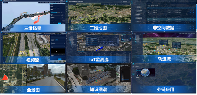
●Provide multidimensional views to visualize non spatial data, panoramic data, graph data, and business data;
●Optimize data caching, transmission efficiency, scheduling strategies, and other strategies to achieve efficient rendering and deep fusion of massive vectors, images, 3D models, and other data;
●Based on unified data management, symbolic representation, visual effects, comprehensive analysis and other functions, achieve integrated expression of 2D views and 3D scenes;
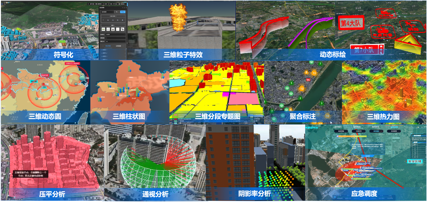
●Support seamless integration of GIS BIM, achieving precise matching between BIM models and geographic spatial scenes. Through professional dynamic slicing, attribute query, road network analysis, path roaming and other functions, promote the deep integration of BIM and GIS, and open up a realistic experience from outdoor to indoor;
●Support the integration of multiple real-time sensor data, and achieve real-time data visualization aggregation through visual effects such as scene deployment, streaming data layers, and scene roaming;
●Multi modal data integration display, realizing dynamic switching of multiple modes of the same data, including 3D models, point clouds, oblique photography models, and other modes;

●Support plugin free 3D client, capable of crossing multiple device terminals and browser kernels.
Integrated Analysis and Application of Full Space Data
The product has the ability of deep spatial insight analysis and integrated analysis of the entire space, achieving multi-dimensional analysis of the entire space.
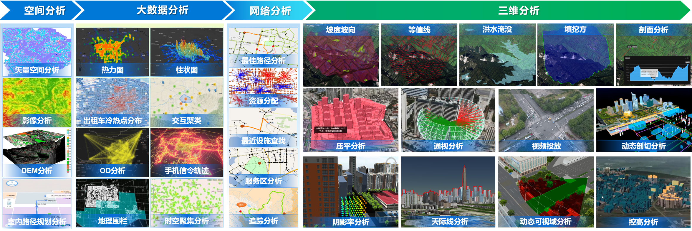
●Provide commonly used spatial analysis widgets, including overlay analysis, buffer analysis, network analysis, overlay analysis, and other commonly used spatial analysis functions;
●Support the calling, execution, and display of analysis results for server-side GIS analysis services such as high-performance GIS analysis, big data GIS analysis, and intelligent GIS analysis;
●Integrating and integrating three-dimensional scenes of the entire space above and below ground, providing terrain analysis, skyline analysis, shadow rate analysis, visibility analysis, visual field analysis, rolling shutter analysis, dynamic sectioning, profile analysis, flattening analysis, height control analysis, model extension, explosion analysis and other three-dimensional analysis functions, providing scientific basis and auxiliary decision-making support for urban planning and supervision, urban space utilization and development
●Enhance the CIM application series of widgets, including various functional widgets such as simulation, planning and design, BIM management, etc.
Full space four-dimensional spatiotemporal simulation
By using various spatiotemporal simulation tools, we can simulate the changes of things in four-dimensional space-time from the three domains of time, space, and attributes, providing a basis for urban development and planning。
●Provide various functional widgets such as visual comparison, spatiotemporal roaming, simulation, scene deployment, etc., to achieve four-dimensional spatiotemporal simulation and comparison;
●Enhance the dynamic plotting series components, providing functions such as industry symbol resource management, dynamic plotting, deduction script production and management, situation deduction, 2D and 3D scene linkage and roaming, etc., to achieve integrated 2D and 3D operations such as industry symbol management, plotting, and situation deduction;
●Provide thematic applications and indicator statistics functions, supporting 2D and 3D server-side and client-side thematic maps such as single value, segmentation, level, and statistics, as well as dynamic and static visualization effects such as heat maps, honeycomb maps, trajectory maps, aggregation annotations, and statistical charts. Combined with data statistical charts, display thematic indicators more intuitively;
●Support multiple 3D particle effects and post-processing effects, bringing more realistic 3D effects expression.

A standardized development framework for an industry icon
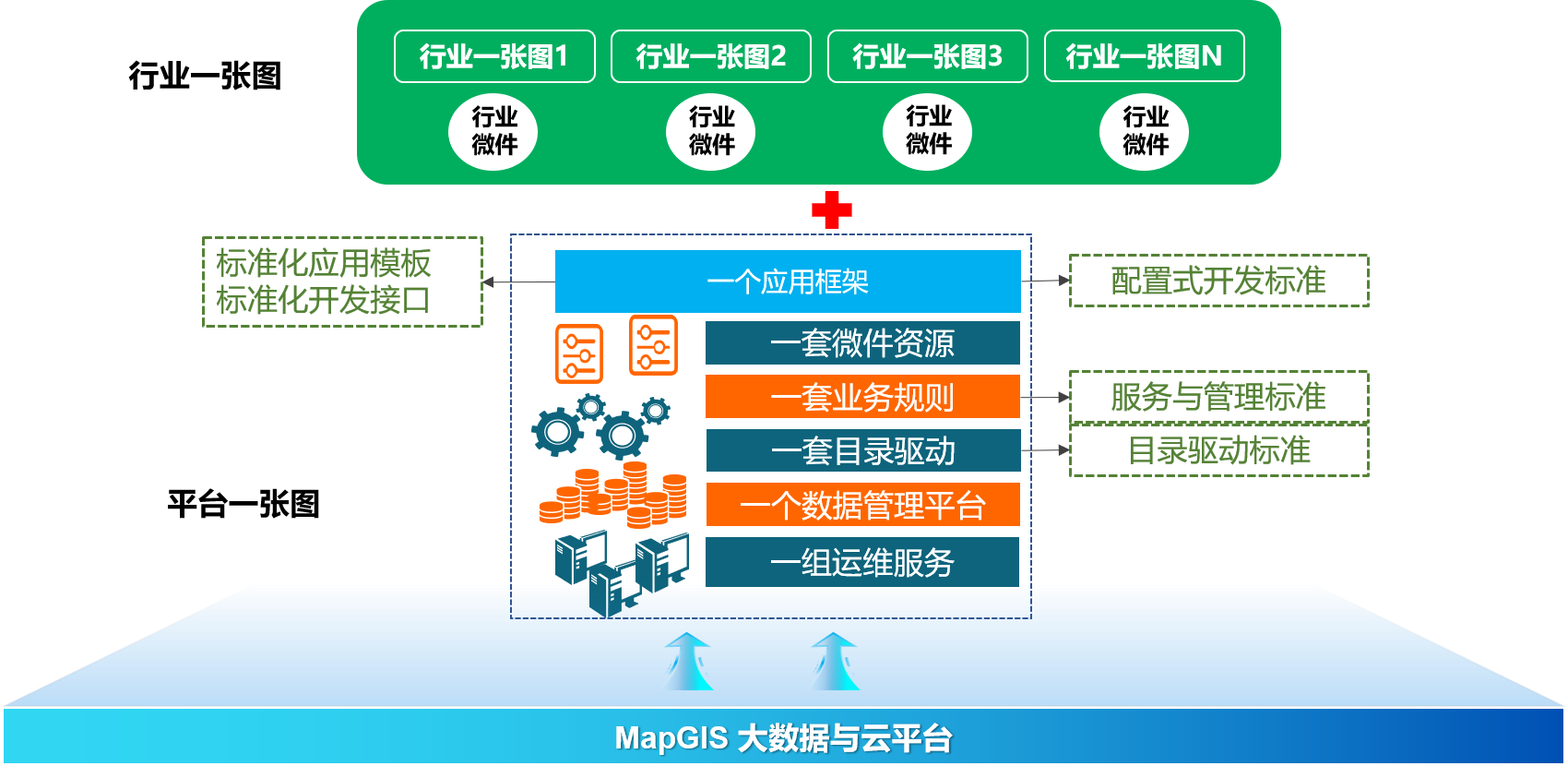
To solve the problem of rapid expansion of a single image in the industry, a new "configuration based" development model has been constructed based on agile development thinking, providing a standardized development framework for "framework widgets" to achieve rapid configuration and deep customization of a single image application.
●Provide a standardized development framework that supports the rapid construction of "one image" applications through configuration, or deep customization of applications based on product source code;
●Provide a visual configuration tool that supports rule visualization configuration and dynamic resource binding;
●Provide a display portal to achieve dynamic parsing and visual expression of rules;
●The product source code is open source, based on GitHub and Gitee hosting core code. Fully assist in the deep customization and rapid expansion of industry applications for a single image.
Related software
Desktop GIS
BD And Cloud Platforms
MapGIS CIM Basic Platform
Digital Twin Platform


