MapGIS Desktop is a professional 2D and 3D integrated desktop GIS product with powerful capabilities in data management and editing, data mapping and visualization, spatial analysis and image processing, 3D visualization and analysis. It is built with the concept of "framework+plugin" and supports on-demand customization.

Picture MapGIS Desktop interface
Product Features
Full space data storage and management
●Through a unified cross platform database engine, it supports open source/commercial databases, local databases, heterogeneous GIS platform databases, as well as domestic databases such as DM, HighGo DB, KingbaseES, PolarDB, YashanDB, etc
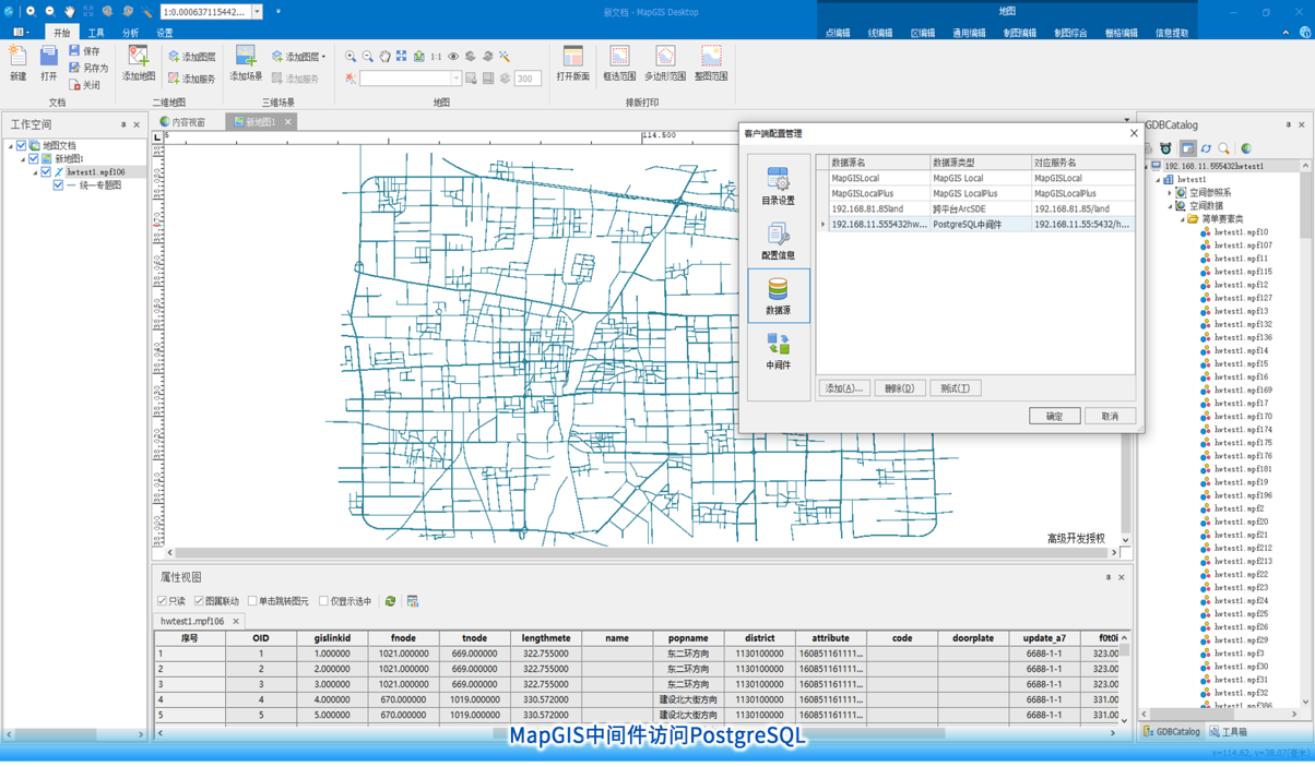
●Support standard based database sharing and direct connection, and can share data sources with heterogeneous GIS. The data model complies with the PostGIS data model specification, and the created geographic database supports third-party GIS software access; Provide PostgreSQL middleware that supports reading PostgreSQL databases created by third-party GIS platforms without changing the data table structure
●Support the management of multi-source and multi type spatial data, including vector, raster, 3D model, terrain, text annotation, layout annotation, network, MapGIS 6x and other types, as well as chart data formats
●Provide embedded dataset models that support the management of tens of thousands and terabytes of segmented images

Picture MapGIS middleware accessing PostgreSQL
Diversified data editing and processing
●Provide 200+map editing and processing tools, 40+topology rules, supporting topology editing, topology error checking, and repair functions
●Provide an extensible data inspection framework and rich inspection and processing tools to achieve automatic data inspection and topology processing
●Provide DRG vectorization tool, supporting fully automatic, semi-automatic, manual and other methods to extract vector points/lines/areas
●Provide semi-automatic vector information extraction tools that support progressive growth extraction of road routes, river surfaces, buildings, natural features, etc

Picture Multi source heterogeneous data processing

Picture Semi automatic vector information extraction
Rich data mapping tools and expression effects
●Provide over 30 map comprehensive processing tools, supporting merging, simplification, small spacing/bottleneck/bend detection, comprehensive quality evaluation, etc
●Provide 2 sets of symbol management mechanisms, independent of symbol libraries, easy to exchange; Support symbol creation, combination, and fast access to symbol libraries on heterogeneous GIS platforms
●Pre set 1000+point, line, and face symbols, supporting SVG image tagging, mixed column lines, gradient filling, and other symbol styles, and supporting TureType font conversion
●Built in discrete, gradient, random and other color schemes, supporting color customization
●Provide various types of thematic expressions such as single value, segmented, heatmap, and grid aggregation graph
Professional map layout output
●Support outputting GeoPDF format
●Support high DPI and large format raster file output, and support color separation output by spot color
Convenient production tool for grid tiles/vector tiles
●Grid tiles support latitude and longitude, spherical Mercator mbtiles、 Custom cutting strategy settings, supporting semi transparent effects, and supporting multi machine distributed cutting
●Vector tiles support cutting strategies such as latitude and longitude, Web Mercator, Gaussian Kruger, and customization
●Grid tile and vector tile production provide multiple storage strategies, supporting local storage, MongoDB storage, and PostgreSQL storage
Integrated 3D data modeling, editing, and visualization
●Provide professional fusion tools that support oblique photography DEM、 Integration and fusion of models and other data
●Provide tools for rule modeling, sloping roof modeling, terrain constraint modeling, etc., supporting batch construction and visualization of 3D models
●Support lightweighting for BIM models LOD、 Combining instantiation and partitioning rendering strategies to achieve lightweight output and high-performance rendering of BIM models
●Support oblique photography model to generate DSM and DOM image data
●Support oblique photography for dynamic and static monoculture. Provide building monolithic and texture mapping tools, support extracting building monolithic models from oblique photography models, and enable building texture mapping
●Provide cache file management, supporting model caching, pyramid caching, refactoring pyramids, M3D merging, 3D cache conversion, Region to M3D conversion, generating Region caching, etc
●Provide M3D cache production tools, support the production of M3D 2.1 cache slices, support point cloud, hierarchical and household data generation of M3D
●Provide 3D particle effects such as fireworks and fountains; Dynamic grassland, water surface and other 3D scene special effects expression

Picture Tilt photography static monoculture

Picture Tilt photography dynamic monomer query

Picture Tilt photography data for building extraction
Efficient data analysis and statistics
●Provide over 30 analysis functions including 2D and 3D spatial analysis, network analysis, 3D scene analysis, DEM analysis, and image analysis
●Support statistical analysis methods such as clustering, regression, gradient, time series, trend surface, principal component analysis, Markov prediction, etc
Powerful data migration capability
●Provide a tool for converting mapping results from heterogeneous GIS platforms, supporting one click conversion of heterogeneous GIS map documents into MapGIS maps
●Provide an upgrade tool for MapGIS 67 mapping results, supporting one click conversion of MapGIS 67 map documents to MapGIS 10 series formats
●Can retain map document attributes, layer organization, layer attributes, symbolic information, thematic information, and dynamic annotations
●Provide source data migration tools that support lossless migration of data containing arc segments, empty geometry, and large text objects

Picture Conversion of Mapping Results from Heterogeneous GIS Platforms
Simple and easy-to-use extension development
●Provide a toolbox with over 200 pre installed GIS processing tools, ready to use and batch run
●Support visual process modeling and low code reuse
●Support for quickly building Python tools and expanding toolboxes

Picture MapGIS Toolbox and Process Construction Process Diagram
Product trial
· Drawing board:http://www.smaryun.com/goods.php?id=2270
· Basic Edition:http://www.smaryun.com/goods.php?id=2271
· Standard Edition(for Oracle):http://www.smaryun.com/goods.php?id=2273
· Standard Edition(for SQL Server):http://www.smaryun.com/goods.php?id=2272
· Premium Edition:http://www.smaryun.com/goods.php?id=2207
Related software
Desktop GIS
BD And Cloud Platforms
MapGIS CIM Basic Platform
Digital Twin Platform


