MapGIS Desktop is a professional 2D and 3D integrated desktop GIS product with powerful capabilities in data management and editing, data mapping and visualization, spatial analysis and image processing, 3D visualization and analysis. It is built using the concept of "framework plugins" and supports on-demand customization.
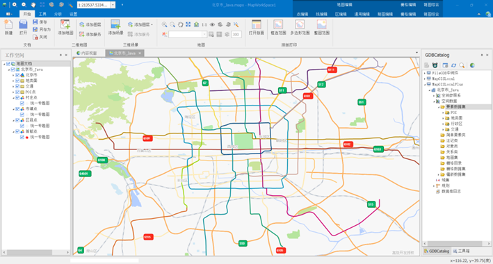
Product features
MapGIS Desktop Advanced Edition supports users to store and manage data based on file databases or network data sources, and provides efficient and intelligent 2D and 3D data production, professional data conversion and processing, rich 2D and 3D data editing tools, professional mapping output, and integrated 2D and 3D analysis functions. It supports vector space analysis, attribute statistical analysis, network analysis, image analysis, and DEM analysis.
(1)Efficient and intelligent vector data production
Provide efficient DRG vectorization tools that support human-machine interaction modes such as fully automatic, semi-automatic, and manual. Choose flexibly based on the characteristics of different data to quickly complete vectorization work. Providing intelligent semi-automatic vector information extraction tools, fully utilizing human target recognition ability and computer's fast computing ability, can not only improve the accuracy of intelligent image interpretation, but also minimize the workload of operators and improve production efficiency.
● Fully automatic vectorization does not require manual intervention, and the system automatically tracks vectors to achieve automatic mapping, which is concise and efficient.
●Provides semi-automatic vectorization capability, adopts human-computer interaction form, and balances vectorization efficiency and vector tracking accuracy.
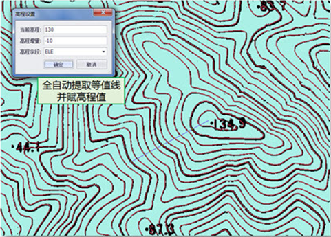
Figure 3: Fully automatic extraction of contour lines and assignment of elevation values
●Provide a semi-automatic vector information extraction tool that supports fast selection, edge adsorption, and semi-automatic extraction. It can interactively and quickly extract features such as buildings, rivers, roads, and natural features (forests, farmland).
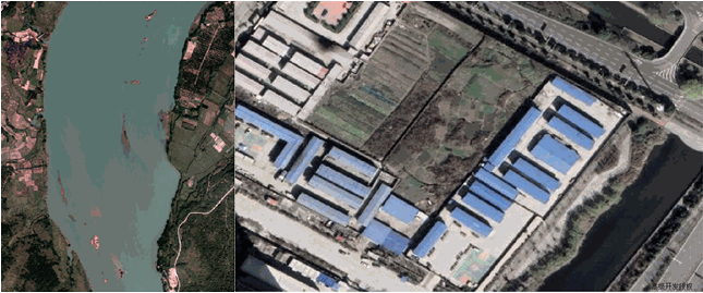
Figure 4 Semi automatic Vector Information Extraction
(2)Convenient and easy-to-use tile and vector tile data production
Provide convenient and easy-to-use tile cutting tools and vector tile production tools, supporting tile and vector tile cutting and updating.
●Diversified tile cutting methods and outputs: Supports cutting strategies such as latitude and longitude, spherical Mercator, and customization. Support setting cropping origin, layer scale, cropping range and other information. Supports the output of three image formats: GIF, PNG, and JPEG. Support saving as *. mut, *. tdf local file type data and saving to MongoDB.
●Intelligent vector tile cropping and output: supports full cropping and intelligent cropping modes. Support output in local muvt or vtdf format, MongoDB storage, and directory file format.
(3)3D modeling of integrated aboveground and underground systems
Provide 3D editing plugins that support integrated modeling of above ground and underground environments.
●Support convenient and low-cost 3D modeling capabilities: Support 3D surface/volume modeling based on 2D vector lines/regions.
(4)Diversified data conversion and processing
Provide comprehensive data conversion and processing tools, professional production functions for national basic scale standard frames and various custom frames, comprehensive coordinate system conversion solutions, support for data unified spatiotemporal conversion, projection coordinate conversion, spatial data and attribute data linkage and other conversion and processing work, support data upgrade, migration and exchange operation functions, and meet various mapping application needs.
●Multi source data migration capability: supports data migration, replication, and transformation between different data sources such as MapGISLocal, database data sources (Oracle, etc.), and various middleware.
●Multi source heterogeneous data access and exchange capability: compatible with MapGIS 67 data, supporting data exchange with MapGIS 67. Supports vector data formats such as Dxf, Shape, Mif, E00, Vct, image data formats such as MSI, tif, img, Dem data formats such as bil, Arc/Info Clear Grid, Surfer Grid, 3D data such as *. obj, *. 3ds, *. dae, *. osgb, point cloud data such as *. las, *. obj, *. xyz, mainstream BIM data such as *. ifc, *. fbx, and commonly used GIS data exchange such as oblique photography data.
●Data model conversion capability: supports vector to grid and grid to vector conversion.
●Data Quality Inspection and Logging Capability: Provides data conversion error checking and automatic error correction functions, as well as a logging system.
●Rich border resources: Provides a border style template editor with up to a hundred parameter settings. Built in national standard scale topographic map frame style, rectangular frame style, and various other commonly used frame styles, ready to use.
●Projection coordinate conversion capability: supports mutual conversion between globally common projection methods, and supports seven parameter/three parameter calculation based on control point files.
●Spatial reference system management capability: supports exporting spatial reference systems, and can quickly export MapGIS spatial reference systems to third-party software for use.

Figure 5 Classification and organization of frames
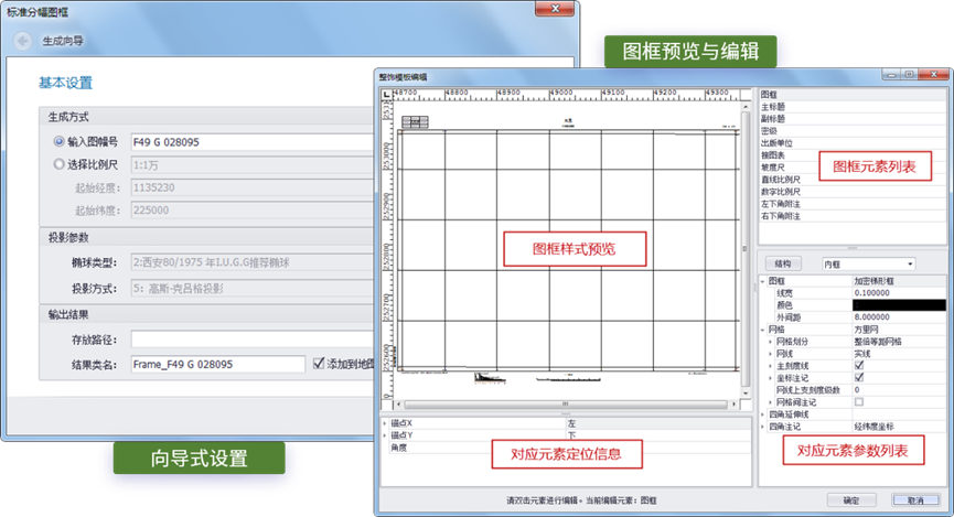
Figure 6 Frame Generation and Editing
(5)Rich and diverse map editing and processing
Provide rich map editing and processing tools, as well as comprehensive map processing tools, supporting the editing and processing of vector, raster, and 3D data.
●Full process coverage, covering the entire application process from data collection, production, beautification to output.
●Provides over 200 vector data editing and processing tools, supporting operations such as adding, deleting, copying, shifting, and rotating geographic entity objects; Support queries for geometry, attributes, conditions, etc..
●Provide rich raster data editing tools, supporting raster data information query, raster data preprocessing, data correction editing, diverse image enhancement methods, and professional image cropping and tiling editing and processing functions.
●Provide simple and easy-to-use 3D editing functions: support model editing functions such as movement and rotation; Support attribute editing functions such as querying statistics and modifying graphic element properties; Support texture, symbol and other graphic editing; Support editing of scene display effects such as particle systems, water surface effects, and video output; Support point cloud addition and deletion; Support scene roaming.
●Provide various map synthesis processing tools, interactive and fully automatic map synthesis processing functions, support fast copying of layer data, support polygon merging, simplification, small spacing/bottleneck/bend detection, simplification, smoothing, extraction of line features, polygon transformation, turning points, comprehensive quality evaluation and other functions.
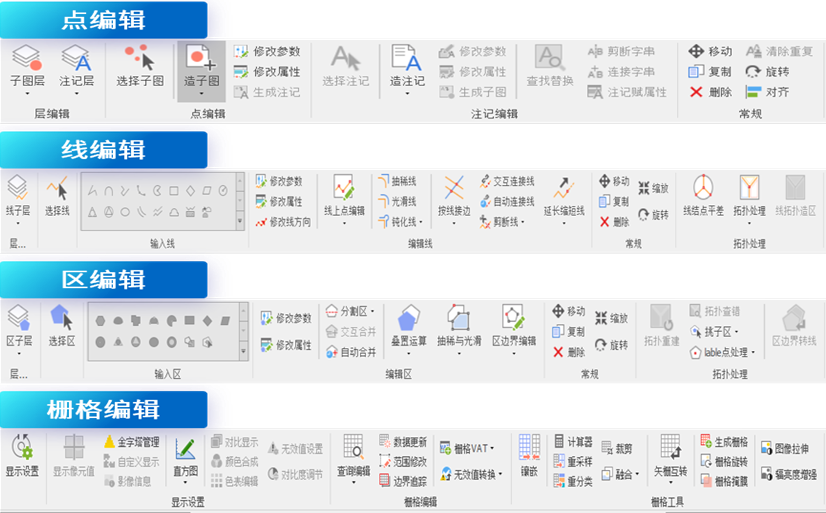
Figure 7 Map Editing and Processing Tool

Figure 8: 3D Editing Tool
(6)Powerful full space data storage and management
Provide powerful data management capabilities, support file databases, multiple mainstream commercial databases, and open source databases, and support storage and management of various spatial data. Support multi-mode modular storage and distributed hybrid indexing, achieve efficient management and fast query retrieval of PB level data, and meet the efficient operation of various functional applications such as data mapping and output, analysis and calculation.
●Support the new file space database MapGIS HDB, support vector, raster, 3D and other data models, lightweight and flexible, suitable for small and medium-sized geographic data usage scenarios such as single machine and data production, can reduce database deployment costs and improve data utilization efficiency.
●Through a unified cross platform database engine, it supports multiple spatial databases such as DB2, Sybase, GBase (Nanjing University of Technology), KingbaseES (Renmin Jincang), YashanDB, etc。
●Supports various data middleware such as ArcSDE middleware, ArcGIS FileGDB middleware, ArcGIS PersonalGDB middleware, and OGR middleware, providing direct reading and display capabilities for spatial data on heterogeneous GIS platforms.
●Provide a complete basic spatial data model that supports points, lines, regions, surfaces, volumes, networks TIN、 Basic spatial objects such as grids and annotations, as well as complex spatial objects such as multi-point, multi line, multi zone, multi-faceted, and multi-body.
●Provides a mosaic dataset model that supports the management of tens of thousands of TB scale segmented images.
●Provides an atlas management model that supports managing spatial data on a graph by graph basis.
●Provides a chart data model that supports chart data storage and management.
●Provides spatial and attribute indexing mechanisms, supporting management such as rectangular range indexing, R-tree indexing, and view frame indexing.
(7)Professional map making and layout output
Provide rich mapping resources, WYSIWYG thematic mapping expressions, professional layout output, to meet the digital mapping needs of different applications and industry standards.
●A comprehensive symbol management system: including 2D symbol library, 3D symbol library, font library, color library, and style library.

Figure 9 Font library, symbol library, color library
●Rich symbol expression effects: preset over 1000 text symbols, dot symbols, line symbols, and fill symbols.
●Flexible symbol extension mechanism: supports custom symbol creation, symbol combination, and quick access to symbol libraries on heterogeneous GIS platforms. Support hierarchical combination of symbols, which can form complex symbols based on the combination of multiple simple symbol layers; Supporting cross type combination of symbols, line symbols can be constructed based on point symbols, and area symbols can be constructed based on point and line symbols.
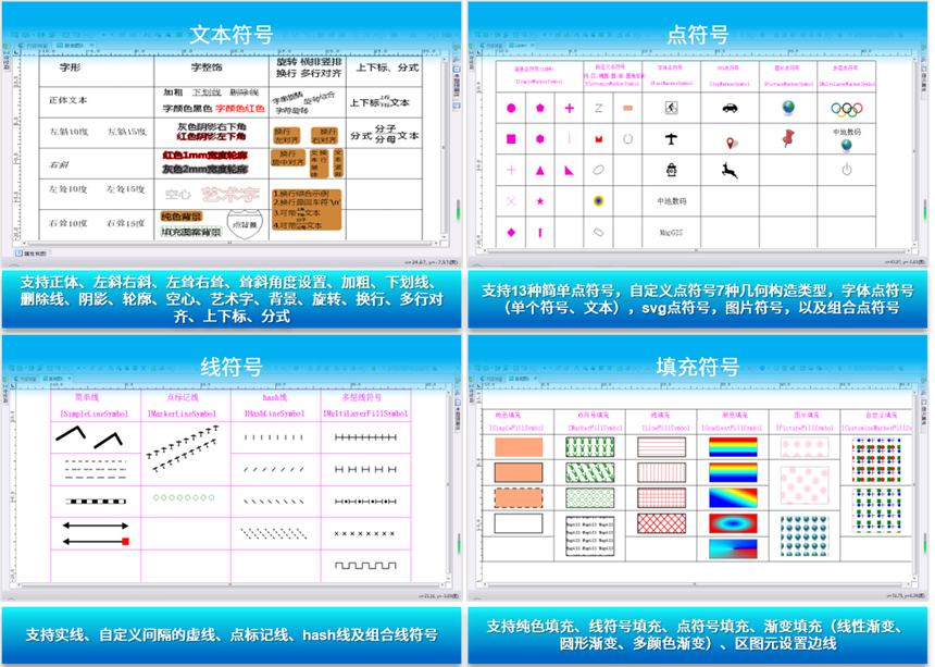
Figure 10 Symbol Expression Effect
●WYSIWYG thematic mapping expression: supports traditional thematic maps such as single value, segmented, and unified thematic maps; Visual representation of big data such as point clustering and heat maps; Grid thematic maps such as single value, segmented, RGB thematic maps, etc. are used for graphic representation.
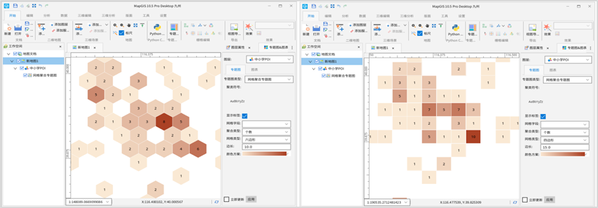
Figure 11: New clustering thematic expression
●Professional typesetting output: providing rich typesetting and decoration tools, and fast typesetting layout. Provides multiple printing methods such as raster files, system, and interactive printing, supporting EPS/PS files, jpg, tif, bmp, png, and other file formats for output. Supports spot color output and large format high DPI output.
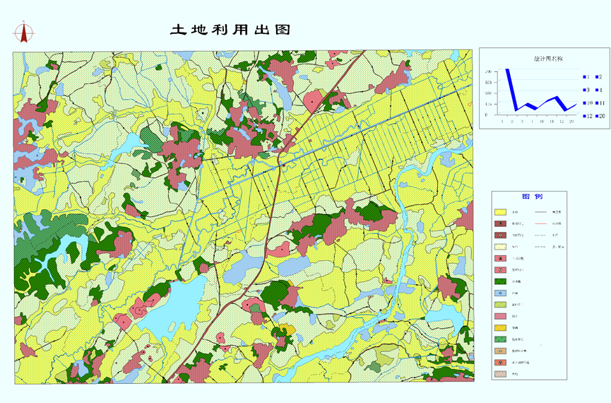
Figure 12 Layout output
(8)Efficient and accurate integrated analysis and statistics of the entire space
Provide efficient analysis functions such as two-dimensional vector space analysis, attribute statistical analysis, network analysis, image analysis, and DEM analysis.
●Provide professional and efficient vector space analysis functions, supporting overlay analysis algorithms such as union, intersection, subtraction, symmetry difference, and discrimination. Support buffering methods such as equal radius left and right, unequal radius left and right, buffering based on specified attribute fields, and multiple buffering radii.
●Provide comprehensive attribute statistical functions: support multiple statistical methods such as counting, frequency, summation, variance, standard deviation, etc. Support multiple attribute filtering methods such as SQL statements and mathematical functions.
●Provide rich chart expression functions: support bar charts, line charts, area charts and other chart types.
●Provide professional attribute statistical analysis methods: support qualitative statistical analysis methods such as cluster analysis, principal component analysis, correlation analysis, as well as quantitative statistical analysis methods such as linear regression analysis, nonlinear regression analysis, time series analysis, trend surface analysis, Markov prediction, etc.
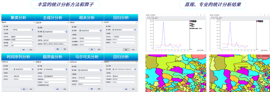
Figure 13 Attribute Statistical Analysis
●Provide efficient network analysis and processing functions, supporting network data editing, topology editing, basic network analysis (connectivity analysis, tracking analysis, path analysis), and application analysis (finding nearest facilities, service scope, optimal routes, multi vehicle delivery, location allocation), etc.
●Provide comprehensive and professional image analysis and processing tools, supporting functions such as image transformation, image analysis, and image classification.
●Provide rich terrain analysis and processing functions, supporting terrain factor analysis, surface analysis, visibility analysis, hydrological analysis, distance analysis, density analysis, TIN conversion, variousthematic mapping (sunshine shading map, density mapping, grid stereo map, etc.) and other functions.
●Provide powerful 3D analysis capabilities: integrate and fuse 3D scenes of above ground and underground spaces, relying on tools such as ground excavation and dynamic sectioning to achieve integrated urban management and intelligent operation of above ground and underground spaces.

Figure 14 Three dimensional analysis
(9)Powerful heterogeneous GIS platform achievement migration capability
Provide heterogeneous GIS platform alternatives for data, symbol styles, and map documents.
●Support the one click conversion of map documents from heterogeneous GIS platforms to MapGIS maps, achieving rapid migration of mapping results from heterogeneous GIS platforms.
●Map document attributes, layer organization, layer properties, symbolic information, thematic information, and dynamic annotation information can be retained.
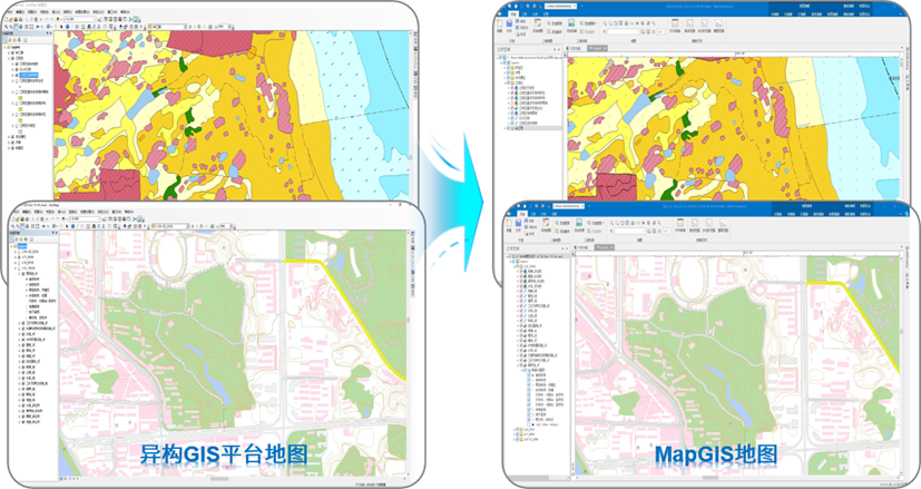
Figure 15 Migration of Heterogeneous GIS Platform Results
(10)Ready to use toolbox
Provide a flexible, fast, and user customizable tool making mechanism.
●Provide over 170 GIS processing tools that are ready to use.
●Support tool extensions based on workflow visualization and Python scripting, which are flexible and efficient.
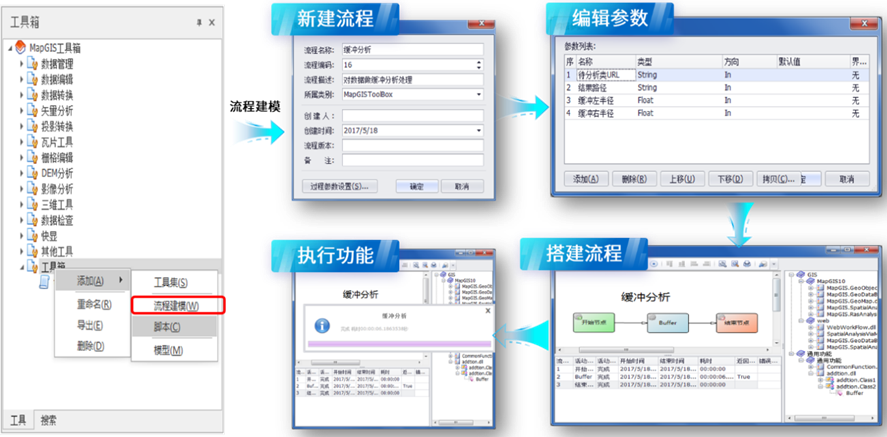
Figure 16 MapGIS Toolbox and Process Construction Process Diagram
Related software
Desktop GIS
BD And Cloud Platforms
MapGIS CIM Basic Platform
Digital Twin Platform


