MapGIS 3D GeoModeler is a tool for 3D geological modeling, visualization, and analysis. It integrates multi-source geological data such as drilling, profiles, and physical and chemical exploration, and uses automatic and semi-automatic rapid modeling techniques to construct structural and attribute models containing complex geological features such as faults and lenses. It realizes the integrated construction of geological models throughout the entire process and provides visualization expression and analysis functions based on geological features.
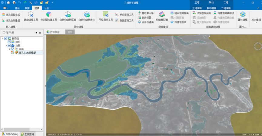
Figure 1 MapGIS 3D GeoModeler interface
Product Features
High precision intelligent modeling of underground space
● Effectively integrating multiple sources of geological data to achieve intelligent construction of geological models that are fully integrated throughout the entire process
● Quickly construct large-scale and high-precision geological models of multi-source large-scale construction areas, solving the problems of low efficiency, large errors, and low accuracy in traditional manual modeling
● Support hybrid modeling method, a new comprehensive modeling technique that adopts modeling of main layer strata and sub layer lithology, suitable for modeling scenarios with disordered distribution of strata and complex geological structures
● Fully integrate the modeling experience of geological experts, introduce expert opinions in the modeling process, and ensure that the modeling form is more in line with the actual geological conditions
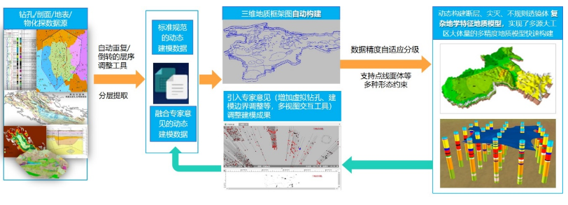
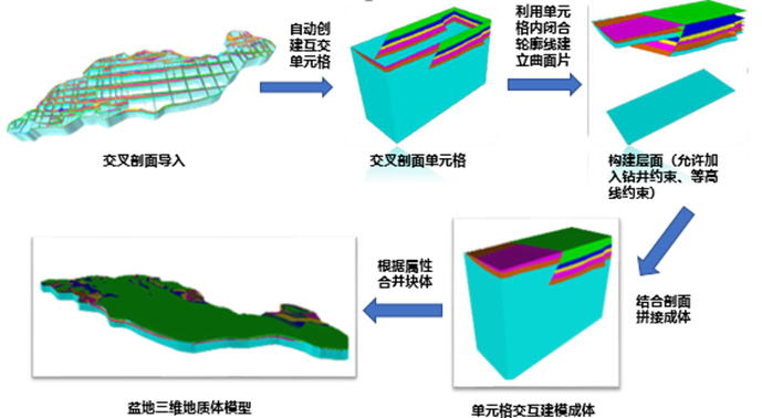
Figure 2 Intelligent modeling process for underground space
Multi precision mesh generation for complex geological models
· Support the subdivision of complex 3D geological models into cascaded grids of multiple accuracies, and the ability to dynamically switch between grid models of different accuracies
· Supports distributed storage and efficient rendering of over 1 billion precision grids, with a rendering frame rate of over 30 frames per second
· Support fast meshing of over 1 billion precision grids, efficiently achieving multi-level attribute queries

Figure 3 Grid subdivision effect diagram
Dynamically update modeling results
· Provide hierarchical point topology editing function, supporting drilling query and display, inserting virtual drilling, and drilling hierarchical point editing
· Provide geological map topology editing function, automatically update associated 3D geological map data by constructing topology and editing node topology information
· Provide a layered processing tool for editing complex lens data to ensure that the modeled form is more in line with the actual geological conditions
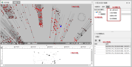
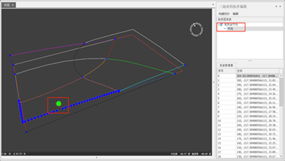
Figure 4: Editing of Layered Points in Drilling Holes Figure 5 3D Geological Map Editing
Product features
Drilling modeling
Provide automatic modeling technology based on drilling data. Based on drilling data as the main source data, using the main Tin modeling idea to quickly construct geological body models, it is suitable for solving modeling problems in situations where the data volume is small, the quality is good, and the geological conditions are relatively simple.

Profile modeling
Providing interactive modeling technology based on profile data, utilizing the powerful 3D editing tool of MapGIS, based on the source data mainly composed of profile data, combined with the interactive stitching modeling idea of expert experience, can solve modeling problems in situations with large data volume, poor quality, and complex geological conditions.
property modeling
Provide a precise and efficient parallel interpolation method based on MapGIS to achieve rapid construction of attribute models, supporting three-dimensional spatial attribute research in fields such as geophysics, geochemistry, and geological environment.
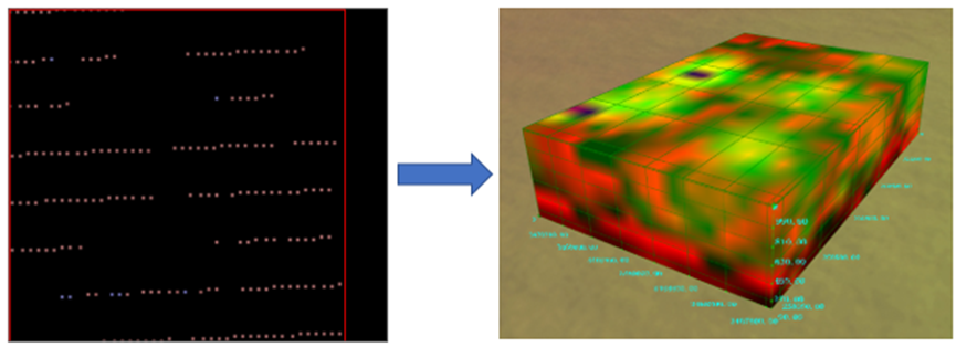
Figure 6 Schematic diagram of attribute modeling
Actual material modeling
Provide automatic modeling technology based on field route data, construct corresponding point line surface models and attitude models based on geological data collected in the field, and achieve three-dimensional geological model construction.
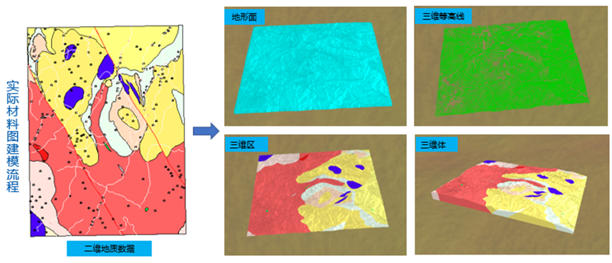
Figure 7 Schematic diagram of actual material modeling
Dynamic modeling in geology
Provide an automatic modeling process based on drilling, which involves setting up data sources, extracting drilling layer information, constructing geological maps, constructing geological layers, and building geological bodies to quickly achieve integrated model construction throughout the entire process
● Support lithological modeling related algorithms, enabling the construction of models for complex geological bodies with repeated inversion within large layers during dynamic modeling processes

Figure 8 Schematic diagram of dynamic modeling
Auxiliary modeling tools
Provide various auxiliary modeling tools, such as hanging surface inspection, node adjustment, layered point topology editing, geological map topology editing, stratigraphic sequence division, etc., to assist in real-time updating of modeling results
Provide 3D topology inspection and processing tools, supporting topology inspection and repair for point and line layers. Three dimensional point inspection includes the requirement that it must be a single part, without duplicate points, etc; 3D line inspection includes inspection items such as being a single part, being a 3D line, and having sufficient coordinate points
Standard Model Data Aggregation
Support the import and export of MapGIS standard modeling sources and modeling results (object classes), facilitating data sharing between MapGIS systems
Support the import and export of GeoXML standard modeling sources (. xml), facilitating the sharing of modeling data with third-party systems.
● Support efficient batch conversion of different types of geological data, enabling flexible utilization of geological data in different formats.
Mesh generation
● Provide a new fast interpolation method for efficient mesh generation of geological structure models
● Support dynamic updating of multiple attributes such as permeability, porosity, groundwater temperature, etc. for multi-level grids, enabling the full utilization of data and modeling results in the project
Provide corner grid and regular hexahedral grid display modes, and support single point and section queries for subdivision results, meeting users' needs for result display and attribute queries
Provide various grid attribute tools, including multi-attribute calculation, attribute switching, attribute filtering, input attribute points, export grid models, and grid model to structural model conversion functions
3D Geospatial Analysis
Based on the characteristics of attribute models, provide functions such as querying, equivalent tracking analysis, attribute value filtering, static cutting, and dynamic cutting to assist in the research of underground attribute features
Provide various professional analysis and evaluation methods, such as cutting, roaming, tracking, dynamic simulation, etc., to provide scientific basis and safety guarantee for the development and utilization of underground space
Provide model space analysis functions, including 3D model overlay analysis, 3D model clipping analysis, 3D model fusion analysis, 3D model buffer analysis, etc
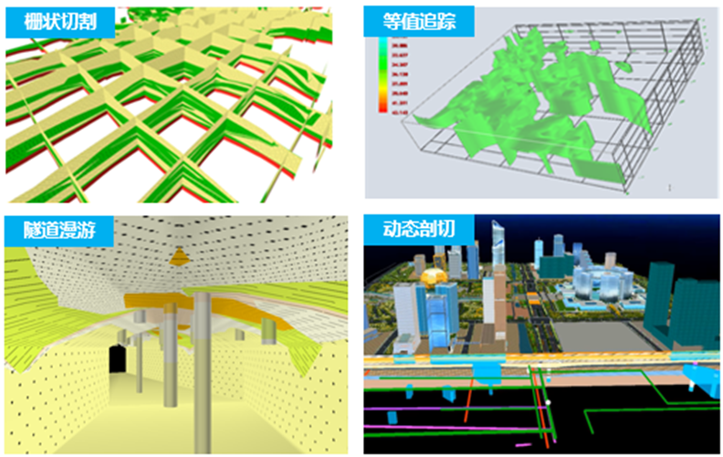
Figure 9 MapGIS 3D Geospatial Analysis
Product trial:http://www.smaryun.com/goods.php?id=2833
Related software
Desktop GIS
BD And Cloud Platforms
MapGIS CIM Basic Platform
Digital Twin Platform


