


Desktop GIS
For desktop GIS application scenarios, we provide 2D and 3D GIS data production, storage and management, editing, mapping and output, visualization, and analysis application functions. These include professional 2D and 3D integrated universal desktop GIS


MapGIS 3D SceneBuilder is a tool for constructing and integrating urban spatial 3D scene models. It enables the aggregation, registration, fusion, and lightweight of multi-source data on the ground and surface, providing data support for professional analysis and application of 3D GIS, and assisting in the analysis and application of natural resource reality 3D, CIM platform, smart city construction, and other 3D specialties.

Figure MapGIS 3D SceneBuilder interface
Product Features

Multi source heterogeneous model aggregation
●Support oblique photography, remote sensing imagery DEM、BIM、 Integrated aggregation and management of multi-source heterogeneous data such as 3D models, laser point clouds, geological bodies, vectors, and IoT perception
●Support multiple storage methods for local data and distributed databases, dynamically adjust data storage strategies for different data, and achieve unified integrated management of multi-source data such as geographic scenes, geographic entities, 3D models, and IoT perception
Multi source heterogeneous model fusion
●Provide professional fusion tools, including coordinate transformation, data registration, Boolean operations, spatial correction, etc
●Support the integrated fusion of full space data such as oblique photography, terrain, images, pipelines, geological bodies, etc
●Support semantic fusion of key semantic information such as layering, structure, and materials in BIM models
Lightweight data output and sharing
●Upgrade industry group standards such as the "Specification for Data Format and Service Interface of Full Space 3D Models" to version 2.1
●Support manual precision modeling, oblique photography data, point cloud data, BIM models, terrain, geological bodies, grid elements, pipeline networks, etc. to generate M3D cache
●Cross platform, supporting integrated applications across desktop, browser, and mobile terminals
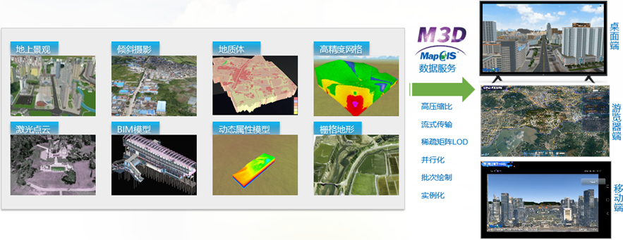
Figure M3D Data Exchange Format
Product features
Quick modeling tool
●Based on 2D data and modeling rules, integrate realistic 3D symbols to achieve batch construction and visual expression of 3D models
●Provide three-dimensional feature representation of over 30 urban components, including real estate buildings, urban roads, urban green spaces, urban landscapes, and infrastructure
●Based on pipeline, pipe point, and attribute data, automatically read feature information to achieve rapid modeling of pipeline and pipe point data
●Support AI based oblique photography for fast monocular reconstruction, achieving automated generation of monocular building models

Figure Monomorphic reconstruction based on oblique photography
Multi source data aggregation
●Support importing multiple data models,Including *.3ds、*.max、*.obj、*. dae、*. Osgb、*.x、*.las、*.off、*.xyz、*.pts、*.ply、*.fbx、*.ifc、*.gltf、*.stl and *.xmletc,Realize direct import and loading preview of multi-source heterogeneous data
●Native support for direct import of BIM model data in Revit format (Revit 2016/2018/2019 version), eliminating the tedious process of configuring conversion plugins, and supporting lossless import of attributes, materials, and semantic relationships of components
●Support lightweight processing of full space models during the import process, achieving fast loading and display of models
3d data processing
●Support 3D path roaming, with parameters such as flight path, observation angle, and roaming model that can be set to achieve terrain or model-based roaming
●Support 3D annotation, including interactive annotation and text annotation/image annotation/graphic annotation/bubble annotation and other types
●Support 3D annotation, including interactive annotation and text annotation/image annotation/graphic annotation/bubble annotation, etc. Support model editing, including model operations such as copying, moving, rotating, scaling, and performing simultaneous scaling on multiple layers. After scaling, the relative positions of each layer remain unchanged
Professional oblique photography processing ability
●Support converting oblique photography files into MCX cache, which can be directly loaded and previewed in 3D scenes
●Support generating DOM/DSM raster data from oblique photography files, extracting building information based on raster data, and achieving monolithic extraction of oblique photography buildings
●Provide professional analysis tools such as model individualization and hierarchical individualization, to achieve graph attribute queries and hierarchical attribute queries of model elements, and assist in urban planning and construction
Professional model fusion ability
●Provide conflict detection tools to detect and adjust situations where the model does not match the terrain elevation position
●Support the integrated fusion of oblique photography, terrain, and models to solve the problem of terrain mismatch in the overlay fusion of terrain, oblique photography, and geological body models
●Support semantic fusion of GIS and BIM models, identifying and integrating key semantic information such as layering, structure, and materials in the BIM model during the fusion process

Three dimensional model lightweighting
●The full space data model standard M3D has been upgraded to version 2.1, providing two methods: M3D attribute external structure and M3D attribute embedded structure, to adapt to different types of full space data
●Support manual precision modeling, oblique photography data, point cloud data, BIM models, terrain, geological bodies, grid voxels, pipeline networks, etc. to generate M3D cache, achieving lightweight output and high-performance rendering of 3D models
●Supports both KTX2.0 and WebP lossy compression and lossless compression for texture compression, and supports default texture and solid color texture styles
●M3D cache supports two types of geometric compression: MeshOpt and Draco
●Support lightweight output of 3D models to achieve efficient and consistent parsing and rendering across desktop, web, mobile, and other platforms
●Support M3D cache conversion to 3DTiles data

3D Professional Analysis
●Support various 3D terrain analyses such as slope analysis, aspect analysis, and flood inundation analysis
●Support rich scene analysis such as visual analysis, field of view analysis, skyline analysis, shadow rate analysis, etc
●Support full space analysis that integrates transparent surfaces, ground excavation, and dynamic sectioning of the ground

Figure Integrated analysis of the entire space
Product trial:http://www.smaryun.com/goods.php?id=2663
Related software
Desktop GIS
BD And Cloud Platforms
MapGIS CIM Basic Platform
Digital Twin Platform


