The product takes "GIS+BIM+IoT" as the starting point to build an open and scalable MapGIS CIM underground space platform product, realizing the integrated management, visual rendering, and processing analysis of all elements of underground space information. It provides a comprehensive product for integrated resource management and sharing, visual display and professional analysis, rapid application construction, and global linkage for the informationization construction of underground space. The platform is built using the "1+1+N" model to create a unified digital base for underground spaces, and to build specialized applications at different business levels to provide services for the construction of underground spaces.
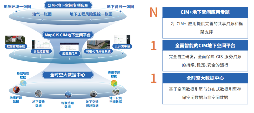
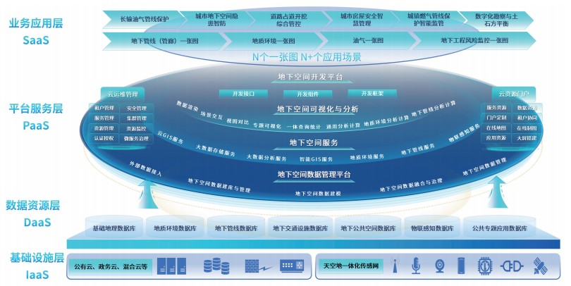
Overall Product Architecture
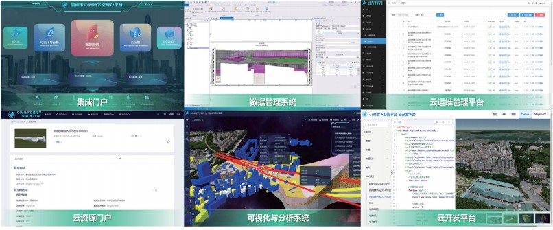
MapGIS CIM Underground Space Platform adopts a layered architecture design, generally divided into infrastructure layer, data resource layer, platform service layer, and application layer. Based on MapGIS cross-platform kernel, it builds five major systems: underground space data management system, underground space cloud operation and management platform, underground space visualization and analysis system, underground space cloud resource portal, and underground space cloud development platform, achieving a full-function system integrating underground space management, application, and development.
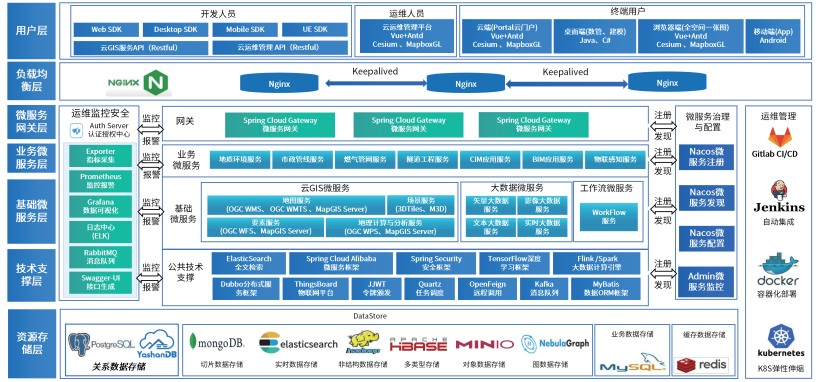
Product Technical Architecture
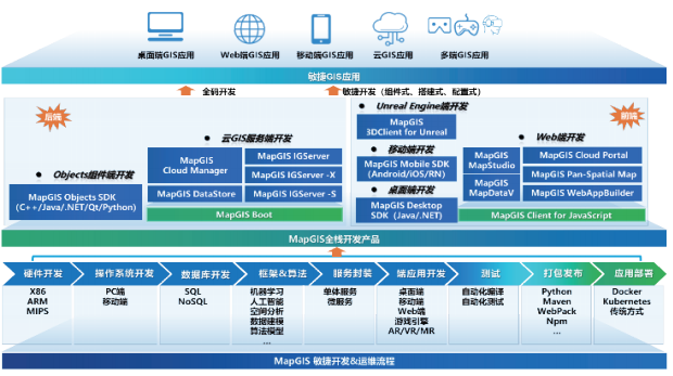
MapGIS CIM Underground Space Platform is based on a cloud-native microservices technology framework, building an advanced and powerful technical framework to provide technical support at multiple levels including data storage, technical support, microservices, operation and maintenance monitoring, operation management, load balancing, and user layer.
Product Composition
MapGIS CIM Underground Space Platform consists of five subsystems: underground space data management, cloud operation management, cloud resource portal, visualization and analysis, and cloud development, covering the entire process from data management → service publishing → operation management → resource sharing → visualization display and analysis → application expansion.

Product Functions
■Data Management System
The underground space data management system is a professional data management system for industry users, providing full-process data management tools including one-click data import, data checking, data processing, data modeling, data fusion, data management, data updating, and data publishing, achieving unified management and maintenance of all-space and all-type data.
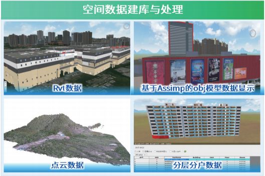
Spatial Data Database Construction and Processing
●Supports various databases including file-based, mainstream commercial, open-source, and domestic databases, as well as heterogeneous GIS databases
●Provides complete spatial data models, supporting TB-level massive spatial data management, access, and retrieval
●Provides various data conversion tools including coordinate transformation, model conversion, and conventional GIS spatial data conversion
●Provides 3D data registration technologies including vector correction, ellipsoid transformation, and projection transformation
●Provides 200+ map editing tools and 40+ topology rules, supporting topology editing, topology error checking, and repair functions
●Provides an extensible data checking framework and various checking and processing tools, achieving automatic checking and topology processing of 2D and 3D data
Spatial Data Modeling
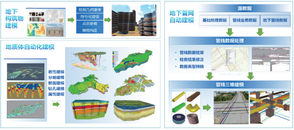
●Provides modeling tools such as rule-based modeling, sloped roof modeling, and terrain-constrained modeling, achieving batch construction of building models
●Based on pipeline, pipeline points, pipeline wells, pipeline networks, and attribute data, achieves batch construction of underground pipeline network models
●Provides high-precision underground space intelligent modeling, which can quickly construct multi-source large-scale multi-precision geological models
●Provides multi-precision grid partitioning modeling for complex geological models, achieving distributed storage and efficient rendering of 1 billion-level multi-precision grids
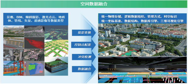
Spatial Data Fusion
●Based on M3D cache, achieves fusion of multi-source heterogeneous data including landscape, oblique photography, BIM, point cloud, geological body, and raster voxel
●Supports lightweight processing and efficient rendering of BIM data through instantiated and non-instanced cache scheduling strategies
●Provides point cloud cache construction tools, supporting the construction of billion-level point cloud caches, achieving efficient rendering of massive colored point cloud data
●Provides static monomerization cutting functions, through semi-automatic extraction and model cutting strategies, achieving rapid extraction of oblique photography model objects
●Provides data fusion tools, achieving full-space data fusion through coordinate transformation, data registration, Boolean operations, spatial correction, etc.
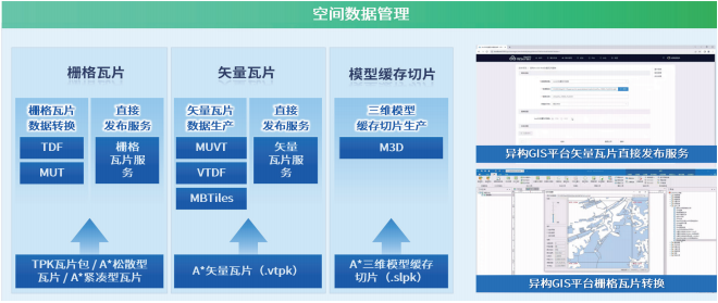
Spatial Data Management
●Provides various analysis functions including vector spatial analysis, network analysis, 3D analysis, DEM analysis, and image analysis
●Introduces technologies such as collision detection, triangle intersection, and adjustment to improve the correctness and efficiency of 3D model cutting
●Provides cache production tools including vector tiles, raster tiles, and model caches, supporting local and MongoDB storage of cache data
●Embedded Python IDE with 200+ preset GIS processing tools, supporting visual process modeling and low-code reuse

■Cloud Operation Management Platform
The cloud operation management platform seamlessly integrates with virtualization and containerization platforms, achieving unified management and operation of multiple resources. Using a tenant mechanism, it realizes "hierarchical management and separate maintenance" of cloud GIS resources, providing professional and concise one-stop operation management services.
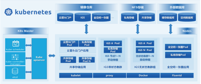
Cloud-Native Microservice Governance
●Built on a cloud-native architecture to establish a unified microservice governance center, providing finer-grained microservice management capabilities
●Based on Kubernetes to achieve automatic container orchestration, realizing automated deployment, management, scaling, and other container control operations
●Provides shared storage, exclusive storage, and external storage methods to meet storage needs of cluster applications and standalone applications
Refined Organization Management
●Achieves refined management of organizational structures based on the tenant mechanism
●Uses hierarchical permissions to achieve resource, service, and cloud application isolation
●Supports comprehensive security mechanisms and log systems for more refined management
Intelligent Cluster Management
●Supports on-demand creation of single or multiple service clusters, with the ability to dynamically join any service node
●Supports elastic scaling, achieving cluster scale elastic scaling by monitoring CPU, memory, and other resource usage rates
●Supports service synchronization and load balancing between cluster nodes
Integrated Resource Management
●Supports unified management of Docker container node resources including big data storage nodes, GIS service nodes, and application nodes
●Supports unified management of service resources including map services, functional services, and extended services
●Supports unified management of application resources including GIS software and industry applications
●Based on metadata management, resource management, and resource catalog functions, achieves resource cataloging and automatic construction of multi-level resource directories
●Provides service registration, service aggregation, and other functions, achieving unified management of various service resources
One-Stop Operation Monitoring
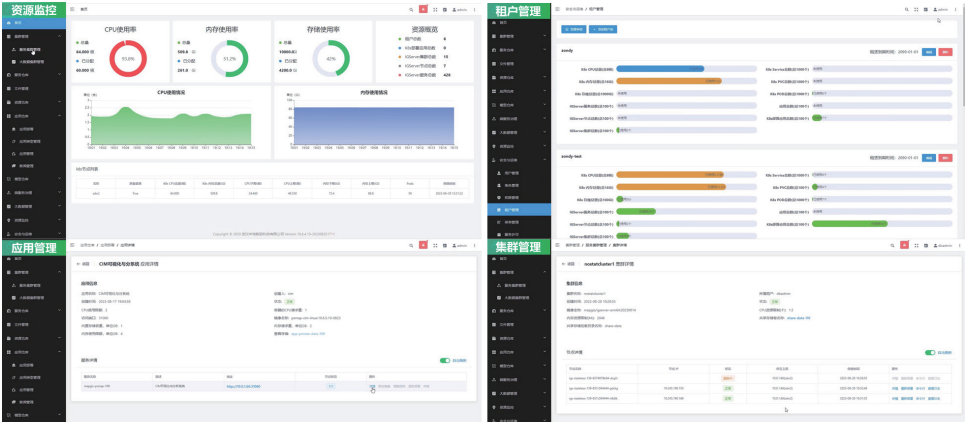
●Provides a visual monitoring management interface, monitoring service resources and hardware/software operation status through dashboards, statistical charts, and other methods
●Supports monitoring alarms and statistical analysis functions, making operation management more convenient
●Supports cloud-native monitoring, including K8s overall, cluster nodes, tenants, PODs, and other resources. By monitoring the real-time usage of CPU, memory, storage, and other resources of these resources, it analyzes the health status of the environment
■Visualization and Analysis System
The visualization and analysis system is based on the all-space information model, achieving integrated management, visualization display, query statistics, analysis calculation, simulation, and professional applications of all-time data including aerial, surface, above-ground, and underground spaces, providing a customizable support framework for "industry one-map" application development.
All-Space Data Integrated Management
●Provides integrated management functions for all-time data including vector, imagery, tiles, models, and raster voxels
●Provides data entity association management functions for spatial data with real-time data, IoT, panoramic, graph data, document data, and other data
●Supports building all-space data directory trees, achieving standardized management and unified access of all-space data services through standard directory methods
All-Space Data Integrated Fusion Display
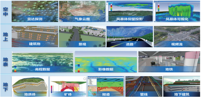
●Provides all-space views, achieving integrated display of all-space data including aerial, above-ground, surface, and underground spaces
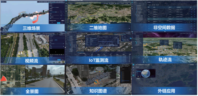
●Provides multi-dimensional views, achieving visualization display of spatial data, non-spatial data, panoramic data, graph data, and business data
Four-Dimensional Spatiotemporal Simulation and Visualization Expression
●Provides functional widgets including visual comparison, spatiotemporal roaming, simulation, and scene projection, achieving four-dimensional spatiotemporal simulation and comparison
●Provides thematic applications and indicator statistics functions, supporting single-value, segmented, graded, statistical thematic maps, as well as heatmap, honeycomb map, trajectory map, aggregated annotation, statistical chart, and other dynamic and static visualization effects
●Provides various 3D particle effects and post-processing effects, achieving more realistic 3D special effects expression
All-Space Data Integrated Analysis and Application
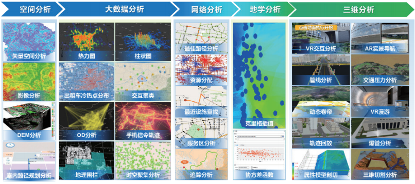
●Provides various server-side analysis functions including GIS spatial analysis, big data GIS analysis, and intelligent GIS analysis
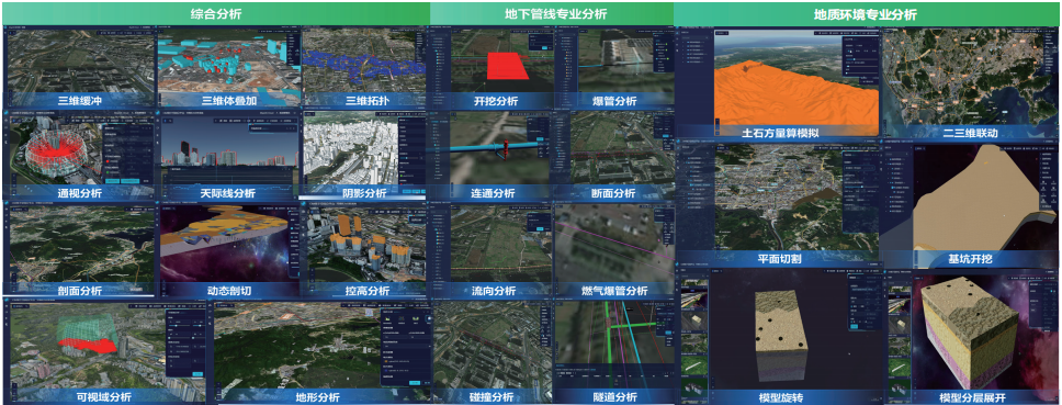
●Provides various client-side comprehensive analysis functions including terrain analysis, model analysis, visibility analysis, and scene analysis
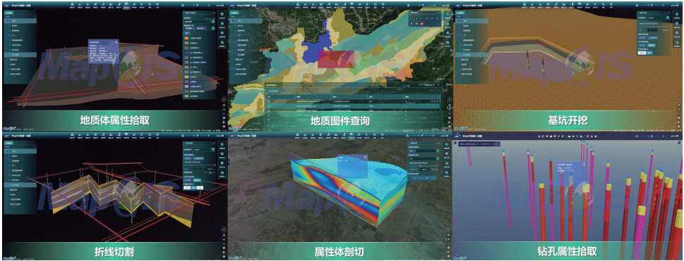
●Provides various geological professional analysis and calculation functions including model cutting, tunnel simulation, virtual drilling, foundation excavation, and earthwork calculation
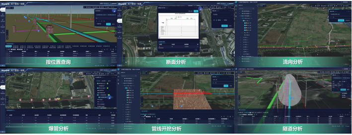
●Provides various underground pipeline professional analysis and calculation functions including pipe burst, collision, connectivity, cross-section, and flow direction
●Provides underground pipeline data checking and detection functions including burial depth detection, aging equipment detection, isolated point checking, and suspended line checking
■Cloud Resource Portal
The cloud resource portal is a comprehensive GIS cloud service portal, achieving integration, rapid search, diverse display, collaborative sharing, and comprehensive management of GIS data, services, maps, large screens, and typical applications. With zero-code customization capabilities, it can quickly customize exclusive GIS portals.
Unified Resource Management
●Integrates resources including data, services, maps, scenes, large screens, and typical applications, achieving unified management of various resources
●Supports custom construction of resource directories, which can be dynamically adjusted as needed, achieving diverse display and online browsing of resources
●Supports rapid search methods including fuzzy search and classification filtering, facilitating users to quickly locate required resources
●Provides online map applications integrating browsing, querying, thematic statistics, visualization expression, and other 2D and 3D functions
Service Collaboration and Sharing
●Manages and monitors service status, service names, and service addresses through resource lists
●Supports group management of GIS resources, achieving resource isolation between different organizations according to organizational methods
●Supports various service sharing methods including public and restricted, achieving shared collaboration between multiple organizations and applications
■Cloud Development Platform
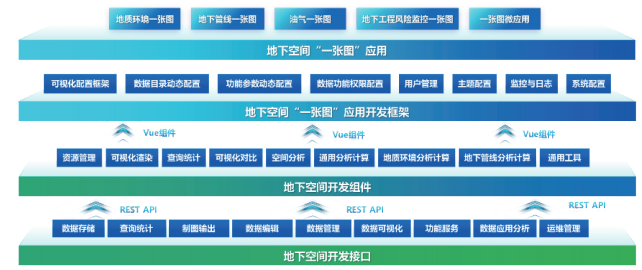
The underground space cloud development platform provides development resources packages including development interfaces, development components, and development frameworks required for CIM+ application development.
Flexible Development Methods
●Supports H5 native JavaScript development and Vue component-based development, making development methods more flexible
●Supports introduction through local offline, CDN online, and NPM installation methods, making project management more convenient
Deeply Integrated Open Source Frameworks
●Integrates open-source map libraries including OpenLayers, Leaflet, MapboxGL, and Cesium
●Deeply integrates visualization libraries including ECharts, ECharts-GL, and MapV, integrating Turf.js client-side calculation library
Efficient Client-Side Computation and Visualization Expression
●Supports client-side computations including buffering, overlay, Voronoi polygons, Tin triangulation, interpolation calculation, and smooth curves
●Supports visualization expression of spatiotemporal static and dynamic data, including heatmap, scatter plot, migration map, O-D map, clustering, and other effects
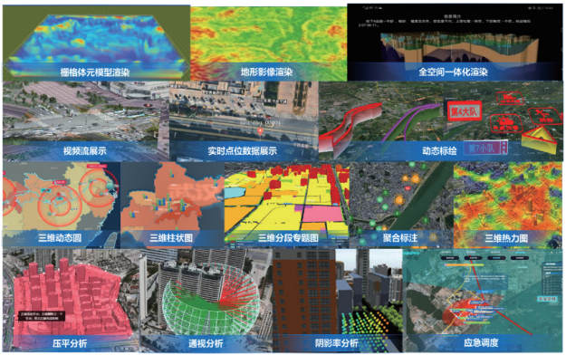
Professional 2D/3D Integrated Analysis and Scene Effects
●Provides 100+ server-side GIS analysis functions including high-performance spatial analysis, 3D analysis, big data analysis, and intelligent analysis
●Provides 30+ client-side analysis functions including vector analysis, terrain analysis, scene analysis, and visibility analysis
●Provides various 3D particle effects and post-processing effects
●Provides spatiotemporal simulation functions including city growth, water accumulation simulation, and building growth
Industry One-Map Standardized Development Framework
●Provides a standardized development framework, supporting configuration-based rapid construction of "one-map" applications, or deep customization of applications based on product source code
●Provides visual configuration tools, supporting rule configuration and dynamic resource binding
●Provides display portals, achieving rule parsing and visualization expression
Product Features
■Multi-Source Heterogeneous Underground Space Data Integration
Aggregates massive heterogeneous underground space data in cities, building a city underground space data circulation system, connecting all links from data collection, aggregation, standardization, modeling, fusion processing, sharing to visualization and analysis, eliminating "information islands" and achieving city space data sharing and multi-terminal collaboration.
■All-Time Data Fusion
Aggregates city data including historical, current, and future data, constructing a unified spatiotemporal framework all-time data fusion system through storage consistency, structure consistency, spatiotemporal consistency, and rule consistency. According to BIM data characteristics, it provides BIM data import tools, achieving precise matching of BIM models and geographic spatial scenes and lossless integration of attributes.
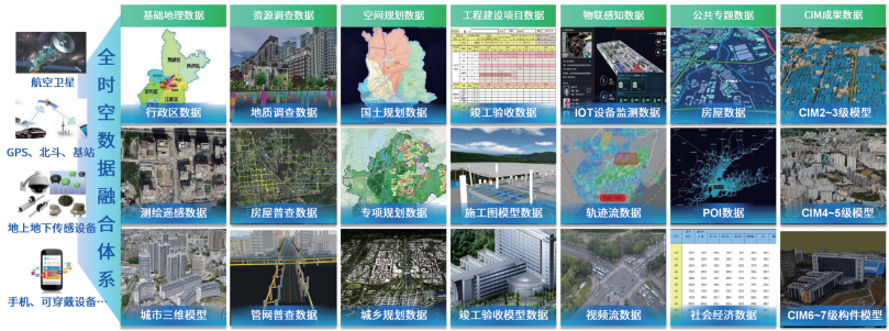
■All-Types IoT Perception Data Access
Supports access and management of all-types IoT perception data, performing indicator monitoring, status monitoring, and data simulation on monitoring data, achieving functions including aggregation, display, and analysis of real-time data, alarm data, and historical data, opening up broader application space for IoT with GIS keys.
■Underground Space 3D Dynamic Modeling
Guided by geological modeling processes, integrating multi-source geological data, quickly constructing complex geological feature models, achieving integrated model construction throughout the entire process, with features including underground space dynamic modeling, high-performance grid partitioning, dynamic updating of modeling results, and large-scale, high-precision modeling of the entire domain.
■All-Time Large-Scene Efficient Rendering
Combining the characteristics of various model data, analyzing and adjusting optimization strategies, providing strategies including node merging, node relationship reconstruction, and texture streaming compression. By constructing M3D2.0 cache, it can efficiently render massive oblique photography, BIM, and other model data.
■Integrated Professional Analysis and Efficient Calculation
Possessing all-space integrated analysis and calculation capabilities, providing functions including visibility analysis, comprehensive analysis, geological environment analysis, and underground pipeline analysis, providing decision support for urban planning, operation, and the entire lifecycle of urban construction and operation, assisting in high-quality sustainable urban development.
■Intelligent Cloud Service Operation
Deeply integrating microservice architecture, providing fine-grained microservices. Seamlessly integrating with virtualization and containerization platforms, supporting rapid deployment of cloud-native GIS clusters and Docker applications.
■Resource Sharing and Multi-Tenant Collaboration Capabilities
Possessing multi-tenant collaboration and resource isolation capabilities, system administrators allocate permissions and resource quotas to tenants, tenants manage their own resources, and can also access resources shared by other tenants, thus achieving "hierarchical management and separate maintenance" of tenant-level resources, achieving the purpose of resource isolation.

■Full-Stack Agile Development Capabilities
Provides development systems including Objects components, cloud GIS services, desktop, and web ends, supporting full-stack GIS application development including terminal GIS, cloud GIS services, and domesticated GIS. Provides agile development methods including component-based, building-based, and configuration-based approaches, supporting low-code or "zero"-code methods to quickly build CIM+ applications.
Product Application Scenarios
■Geological Environment One-Map
The geological environment one-map application integrates existing geological data resources in cities, providing functions including data management, query display, model cutting, terrain analysis, and scene effects, achieving management and query of related process data, result data, and analysis data, leveraging the pioneering and foundational role of geological work to serve sustainable urban development.
■Underground Pipeline One-Map
Combining the actual needs of urban pipeline management departments, pipeline operating enterprises, construction project management departments, and the five-party main responsibility of construction projects, building a pipeline one-map system based on CIM. This system provides functions including data management, pipeline network display, pipeline network query statistics, pipeline checking, pipeline detection, and pipeline analysis.
■Oil and Gas Pipeline One-Map
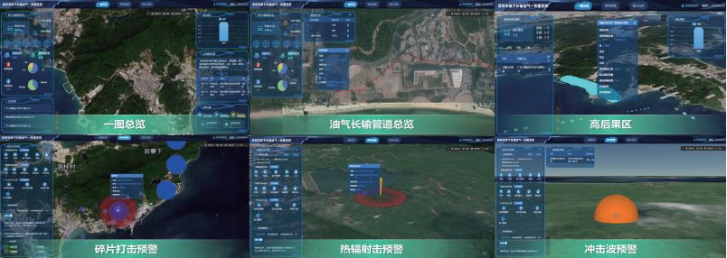
Oil and gas pipelines passing through densely populated Level III high-consequence areas are extremely likely to cause mass casualties and injuries once an accident occurs. Therefore, the oil and gas pipeline one-map achieves risk assessment of urban lifelines themselves and secondary derivative risks by modeling oil and gas pipelines in 2D/3D and modeling above-ground and underground environmental facilities in high-consequence areas. By accessing front-end perception and monitoring data, it achieves risk judgment and early warning, and pushes effective emergency response information.
■Underground Engineering Risk Monitoring One-Map
The three-stage risk control of construction projects refers to risk assessment, monitoring and early warning, and hidden danger investigation and management conducted in three stages: before, during, and after underground engineering construction, targeting the disturbance risks of underground engineering construction to the surrounding environment. This system focuses on the most typical shield tunneling projects in Shenzhen's underground engineering, relying on the MapGIS CIM underground space platform to build a full-process risk control system for underground engineering with closed-loop processes including risk identification, risk perception, risk response, and risk prevention.

■Urban Underground Space Hidden Danger Intelligent Prevention
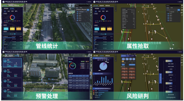
With the continuous expansion of urban construction scale, urban underground pipeline networks are becoming increasingly complex, putting great pressure on pipeline network management. By building an urban hidden danger intelligent prevention system, it achieves comprehensive management of underground pipeline network information, hidden danger monitoring of various pipeline networks, early warning and disposal, ensuring the safety of people's lives and property.
■Urban Building Safety Intelligent Management
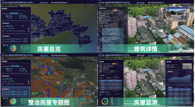
Targeting the hidden danger problems of self-built houses illegally renovated for business purposes, through a building safety management platform, it achieves visual display and statistical analysis of self-built houses, including basic building information, investigation, appraisal, super high-rise buildings, dangerous building rectification, building attributes, etc., completing dangerous building video monitoring display and AI early warning information statistics and rectification business closed-loop tracking.
Typical Cases
■Deqing Intelligent Connected Vehicle Cloud Control Platform
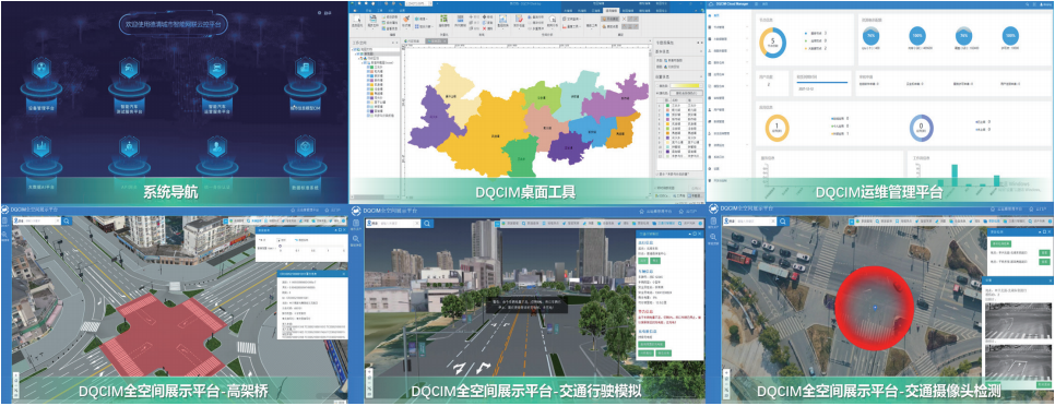
The Deqing Intelligent Connected Vehicle Cloud Control Platform project uniformly aggregates information reported by roadside infrastructure, vehicle information, weather conditions, traffic conditions, high-precision maps, and other data. Through big data analysis, it provides data service capabilities, ultimately supporting the application expansion of intelligent vehicle testing and operation, supporting the development of vehicle-road collaboration applications and smart travel applications in demonstration zones. The project undertakes edge cloud entities including intelligent infrastructure perception systems, vehicle networking systems, and edge computing systems, and connects to various application demonstration projects above, being a key system for expressing the capabilities of demonstration zones. The project consists of three subsystems: DQCIM desktop tools, DQCIM operation management platform, and DQCIM all-space display platform. The three systems complement each other, comprehensively supporting intelligent vehicle testing and operation, meeting the needs of city-wide urban-level autonomous driving and smart travel.
■Shenzhen CIM Underground Space Application Pilot Project
Relying on the existing achievements of Shenzhen's city-wide spatiotemporal information platform, through data collection, inspection, cleaning, and centralized aggregation of city-wide geological, pipeline, underground transportation facilities, underground public facilities, and other underground space data, it forms a unified underground space data service for the entire city. Through data governance, it ensures the integrity, accuracy, and timeliness of data. The project includes five subsystems: data management system, cloud operation management platform, cloud resource portal, visualization and analysis system, and cloud development platform, integrating application scenarios including underground long-distance oil and gas pipeline one-map, urban gas pipeline protection intelligent supervision, geological environment one-map, three-stage risk control of construction projects, and comprehensive control of road occupation excavation.
Related Software
Smart City
- Smart City Spatiotemporal Big Data Platform
- MapGIS Smart Thermal Solution
- Smart Emergency Command Platform
- MapGIS Field Work Order Solution
- Enterprise One Picture Solution
- Smart Security Combat Platform
- MapGIS Pipeline GIS Solution
- Smart Chemical Industrial Park Solution
- Smart Patrol and Prevention Platform
- MapGIS Integrated Management System Solution for Underground Municipal Facilitie
Natural Resources
- National Land Space Basic Information Platform: Smart Hub
- National Spatial Planning Implementation Monitoring Network (CSPON)
- Real estate convenience service system
- Realistic 3D Solution
- Natural Resource Asset Management Solution
- One code land management solution
- Ocean monitoring solutions
- Intelligent Disaster Management Solution
- Integrated solution for natural resources e-government
- Land survey solution
Smart Geology
- MapGIS Digital Twin Watershed Solution
- MapGIS Groundwater Informatization Solution
- MapGIS Iterative Geological Modeling Tool
- Geological Informationization Solution
- MapGIS Geological Data Management and Display System
- MapGIS Field Data Collection System
- MapGIS Smart Environmental Protection Solution
- Integrated solution for urban geology above ground and underground
- Geological big data cloud platform
- MapGIS Mining Management and Modeling System
More Applications
- Series solutions for the communication industry
- MapGIS CIM Underground Space Platform
- Smart wind power solution
- Solution for Radio and Television Resource Management
- Transportation Meteorological Support Service Solution
- High performance processing solution for remote sensing images
- Multi source remote sensing data management solution
- Solution for Multi source Meteorological Information Integration Application and Service Platform
- Solution for Visualization Platform of Meteorological 3D Storm Body Echo Data
- Solution for Weather Radar Construction Business Platform


