


Smart City
The MapGIS Park One Map Solution is aimed at government regulatory agencies, using GIS one map as the base map and guided by improving per mu efficiency. By summarizing data on the park's geographical location, number of enterprises, key projects, output value, taxation, etc., it constructs a park one map management platform that integrates intelligent planning, investment attraction, project construction, and industrial supervision.
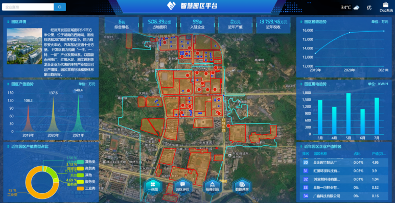
One Map Visualization
Based on GIS, dynamically display spatial positioning, contours, partitions, attributes, and spatial distribution information of various parks and enterprises, presenting the spatial pattern and development status of industrial parks.
Map-Based Park Management
Effectively manage park boundaries, corporate plots, and idle land, resolving issues such as unclear park boundaries, non-compliant land use, and lack of transparency in corporate operations.
Big Data Assists Park Development Decision-Making
Fully leverage the functions and roles of big data and cloud services to accurately grasp the overall planning and construction status of industrial parks, making parks a key engine for high-quality economic development.
Core Values

Related Software
Smart City Space Time BD
Smart Policing
- Smart Emergency Command Platform
- Smart Security Combat Platform
- Smart Patrol and Prevention Platform
- Security Command and Dispatch Platform
- Smart Police Station Platform
- Integrated Border Defense Practical Platform
- Public Security Time Space Information Cloud Platform
- Mobile policing practical platform
- Integrated platform for emotional guidance and action
Smart Municipal Administration


