


Smart Municipal Administration
Based on the MapGIS spatiotemporal base, with underground infrastructure data as the core and deep integration of the City Information Model (CIM), an expressive infrastructure and hazard data information base map is constructed to support real-time monitoring, simulation, accident warning, and provide intelligent information services for underground space planning, construction, management, and updates.
The MapGIS comprehensive management system solution for underground municipal facilities, guided by the "Guiding Opinions on Strengthening the Construction of Urban Underground Municipal Infrastructure" issued by the Ministry of Housing and Urban Rural Development, is based on the MapGIS spatiotemporal base, with underground infrastructure data as the core, deeply integrated with the City Information Model (CIM), to construct an expressive infrastructure and hidden danger data information base map, supporting real-time monitoring, simulation, accident warning, and providing intelligent information services for underground space planning, construction, management, updates, etc.
Urban Underground Municipal Infrastructure Management Platform
Based on the urban underground municipal infrastructure data management platform and unified data standards, utilizing multi-source heterogeneous technologies, an efficient mechanism for data library construction, inspection, updating, modeling, management, application, and publishing is established to meet users' diverse data management application needs and achieve dynamic maintenance and management of data.

Urban underground municipal infrastructureFacility monitoring and early warning platform
Based on the comprehensive management platform of urban underground infrastructure, we will build monitoring and early warning functions for urban underground infrastructure, serving application scenarios such as underground infrastructure operation monitoring, risk identification and judgment, emergency command and disposal.

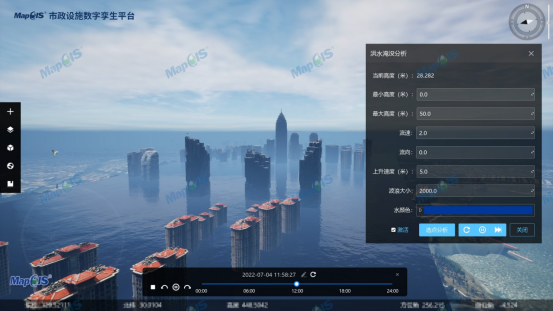
Digital Twin Platform for Urban Underground Municipal Infrastructure
Deeply integrate the comprehensive management platform of urban underground municipal infrastructure with the urban information model (CIM) basic platform, achieve the digitization and virtualization of all elements of urban underground municipal infrastructure, and realize multi-dimensional intelligent analysis and prediction. Establish intuitive and dynamically controllable digital twin scenarios to provide scenario simulation, daily management, and decision-making support for refined asset management and in-depth business applications.
Related Software
Smart City Space Time BD
Smart Policing
- Smart Emergency Command Platform
- Smart Security Combat Platform
- Smart Patrol and Prevention Platform
- Security Command and Dispatch Platform
- Smart Police Station Platform
- Integrated Border Defense Practical Platform
- Public Security Time Space Information Cloud Platform
- Mobile policing practical platform
- Integrated platform for emotional guidance and action
Smart Municipal Administration


