MapGIS Information Creation Integrated Machine Solution
Driven by the joint efforts of national policies and enterprise technological innovation, the information and innovation industry has officially entered the stage of "real for real" application deepening and landing, and the integration of software and hardware has emerged. Led by new quality productivity, Zhongdi Digital, in collaboration with Kirin and Huawei, has taken the lead in launching a full stack information and innovation GIS all-in-one machine. Through standardized integration, all-round adaptation, and fine tuning, it has created a high-performance MapGIS information and innovation all-in-one machine solution that is ready to use out of the box. It solves the problem of difficult adaptation, migration, transplantation, and deployment of domestically produced GIS substitutes, lowers the threshold for user use, promotes the upgrading of information and innovation GIS from functional to functional, and accelerates the landing of "2+8+N" information and innovation GIS.
In order to fully meet the demand for GIS replacement and upgrading in industries such as education, geological exploration, and natural resources, as well as the needs of government and enterprise digital intelligence construction, university research, and personal applications, we focus on digital mapping, service sharing and application development, and rapid construction of spatiotemporal data bases in the information and innovation environment. We have launched three major integrated machine products: the information and innovation map mapping integrated machine for digital mapping core business, the information and innovation GIS server integrated machine that provides full GIS service resources and development support, and the information and innovation big data and cloud platform integrated machine with comprehensive capabilities of cloud GIS platform.
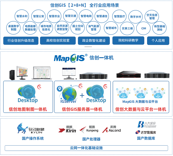
MapGIS Information Creation Integrated Machine Solution Architecture
Xinchuang Map Drawing Integrated Machine
The Xinchuang Map Mapping Integrated Machine is the preferred solution for the core business of digital mapping. Based on the Huawei Kirin 9000C/9006C, Galaxy Kirin desktop operating system V10, and domestic databases such as Renmin Jincang or Dameng, the software and hardware infrastructure base is equipped with MapGIS Desktop (Kyushu) software. Multiple software and hardware deep integration strategies are adopted to finely polish it into a high-performance and cost-effective desktop GIS information and creative all-in-one machine, providing simple, efficient, and professional one-stop digital mapping services for cartographers and others. The goal is to create a new era of information and creative icon pole products after MapCAD.
Product Configuration

Product features
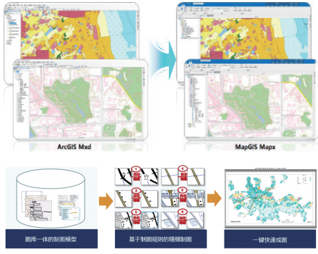
MapGIS Desktop (Kyushu) is a professional cross platform desktop GIS product and an excellent map digital mapping software with professional mapping, data processing, analysis, and application capabilities.
●Full space integrated storage management
●Intelligent data editing and processing
●Professional mapping and expression skills
●Migration of Mapping Results from Heterogeneous GIS Platforms
●Powerful 2D and 3D integrated applications
●Diversified and efficient customized development

Core value
●Ready to use: XinchuangMap mapping all-in-one machine is ready to use out of the box, with zero user barriers, no need for software or hardware adaptation, no need to install and deploy software, freeing up IT productivity and allowing users to focus more on business
●Full alignment:Deeply integrated with software and hardware such as the Galaxy Kirin system and Huawei Kirin chip, benchmarking against similar GIS tools from non information and innovation industries, aligning software functions and performance, fully adapting and optimizing, ensuring robust, leading performance, safe and controllable core mapping functions
●Cost-effective:Provide specialized, automated, and intelligent digital mapping functions, with full space data processing, analysis, and application capabilities, powerful functions, one-stop whole machine delivery, time-saving and labor-saving, highly cost-effective
Xinchuang GIS server all-in-one machine
Focusing on the origin of server GIS, Zhongdi has joined forces with major companies such as Kirin and Huawei to create a powerful solution for integrated GIS servers, which is recommended as a solution for server GIS innovation and upgrading. Based on Huawei Kunpeng 920, Galaxy Kirin Advanced Server Operating System V10, and domestic databases such as Renmin Jincang or Dameng, the software infrastructure base is equipped with MapGIS IGServer (Kyushu) software, which achieves comprehensive optimization of the performance of spatial data services. It is a GIS server all-in-one machine with full functionality, high performance, high availability, high guarantee, and low threshold core values, becoming a powerful tool for spatial data service sharing and application construction in the information and innovation environment.
Product Configuration


Product features
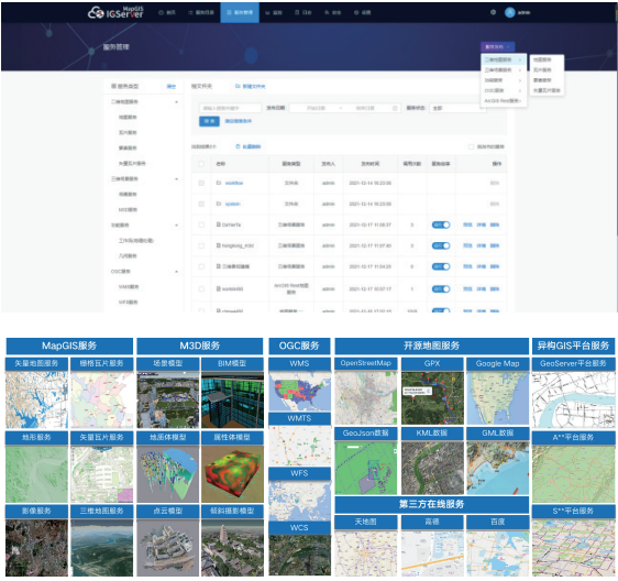
MapGIS IGServer (Kyushu) is a cross platform high-performance GIS server product and a platform software for browser based GIS application and development. It has the ability to publish, manage, expand, and provide full-featured GIS services, providing integrated 2D and 3D spatial data visualization, editing, analysis, and other functions. It supports efficient construction of full space WebGIS applications for various industries.
●Cloud native integration, cross platform system
●Efficient service expansion methods
●Refined service management mechanism
●Aggregatable multi-source heterogeneous GIS services
●Comprehensive high-performance GIS service sharing
●Comprehensive support for multi terminal application development
Core value
●High performance:Combining the strength of domestic software and hardware giants such as Kirin and Huawei, with the support of full stack technology, focusing on service performance optimization, the performance improvement of 2D and 3D service loading and querying in non innovation environments can reach 10% -30%
●High availability:Deeply integrating software and hardware facilities such as Kirin and Kunpeng to create a fully functional GIS server all-in-one machine, providing efficient, stable, secure, controllable, and flexible GIS services to better support service sharing and application construction needs
●High-availability:Develop a comprehensive migration tool and layer by layer replacement solution that guarantees "fast, precise, and accurate" migration, to quickly achieve seamless migration of data, services, and applications, and provide full cycle migration support services for the replacement and upgrade of information and innovation GIS
●Low threshold:提A GIS server integrated solution for overall packaging, pre installed with rich supporting resources such as APIs and examples, reducing the technical threshold for users and meeting the full scenario application needs of various users
Xinchuang Big Data and Cloud Platform Integrated Machine
Xinchuang Big Data and Cloud Platform Integrated Machine is a hyper converged cloud GIS platform integrated solution product jointly developed by China Land, Qilin, Huawei and other ecological partners. It is the preferred solution for the construction and application of national production spatiotemporal data base. Based on the Huawei Kunpeng 920 (and Ascend) processor, Galaxy Kirin advanced server operating system V10, and domestic databases such as Renmin Jincang or Dameng, the software and hardware infrastructure base is equipped with MapGIS big data and cloud platform, integrating a series of software and supporting resources, and launching a one-stop delivery, intensive application, and high standard service for high-end government and enterprise users.
Product Configuration

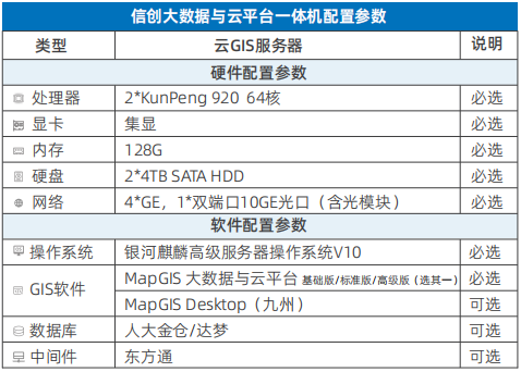
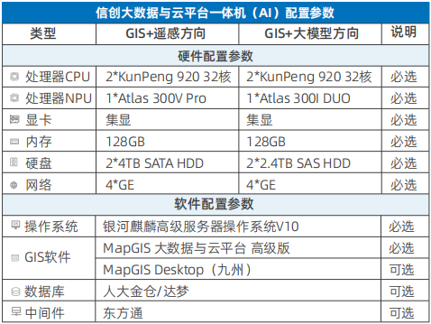
Product features
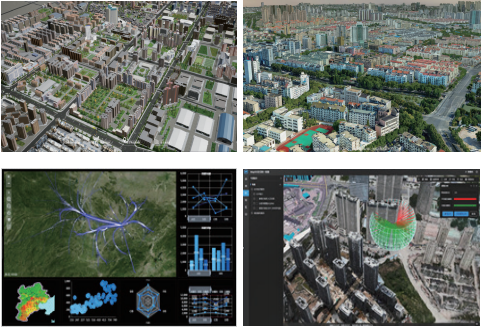
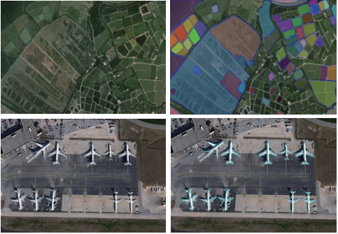
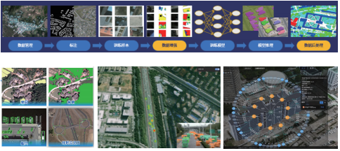
MapGIS Big Data and Cloud Platform is an integrated cloud GIS platform product, supported by five technical systems: cross platform, full space, big data, artificial intelligence, and full stack development. It relies on a series of software products including cloud storage, cloud servers, cloud operation and maintenance management, and cloud applications, and has integrated spatiotemporal big data storage, computing, operation and maintenance, and application capabilities. It provides integrated storage and efficient management of spatiotemporal big data, high-performance and diversified map services and analysis services, realizes intelligent cluster deployment and operation and maintenance management, and meets the online sharing and collaboration of various GIS resources.
●Integrated storage based on hybrid database
●Standardized governance of the entire lifecycle of geographic big data
●Distributed and efficient analysis of geographic big data
●Multi style cool expression of geographic big data
●Map service does not slice real-time rendering
●High performance rendering of full space data
●Visual Intelligent Modeling and Scientific Computing
●One stop cloud service operation and maintenance management
●Online collaboration for the entire process of business
●Full stack agile development
Core value
●One stop delivery:A hyper converged cloud GIS platform integrated product that focuses on building application scenarios for spatiotemporal data bases, achieving one-stop delivery, one click deployment, and intelligent operation and maintenance
●Intensive application:Build a unified and intensive cloud GIS service platform, highly integrating a series of software including cloud storage, cloud services, cloud operations and maintenance, and cloud applications. Build in a modular and on-demand manner, greatly reducing users' construction and operation costs
●High standard service:Deeply compatible and integrated with software and hardware such as Galaxy Kirin, Huawei Kunpeng (Ascend), Renmin Jincang, and Dameng, fully unleashing the service efficiency of cloud GIS platform, and solving the challenges of high availability, high performance, high stability, and elastic expansion of cloud GIS platform in the information and innovation environment
Solution Advantages
◆Based on the all-in-one machine equipped with MapGIS Kyushu National Production GIS Platform software, the software and hardware are deeply integrated, fully adapted and optimized, providing users with a stable, safe, high-performance, and low threshold one-stop integrated solution for information and innovation GIS. It provides a better choice for the upgrading and transformation of information and innovation in industries such as education and geological exploration
◆Joining forces with domestic software and hardware manufacturers such as Kirin and Huawei, fully tapping into the potential of software and hardware integration between MapGIS software and the combination of "Kirin/Kunpeng/Ascend chips+Galaxy Kirin system+Renmin Jincang or Dameng domestic databases", leveraging the advantages of the information and innovation ecosystem, and comprehensively improving the efficiency of information and innovation GIS software


